

Strange Mysteries
A
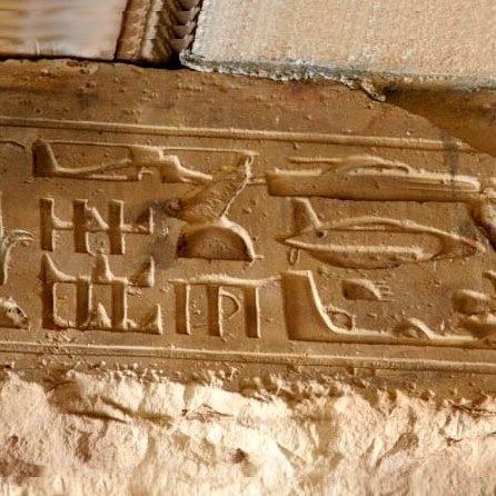
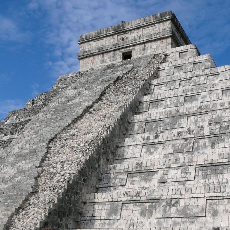
Abydos Helicopter
1300 BC
Egypt - Abydos
26 11' 05.03" N, 31 55' 09.45" W
Helicopter Abydos
In addition to the image of the helicopter, we also see a military tank or submarine, and a strange aircraft.

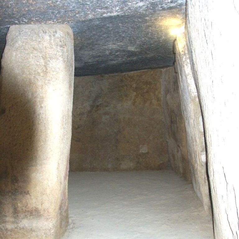
Helicopter Temple Seti-I
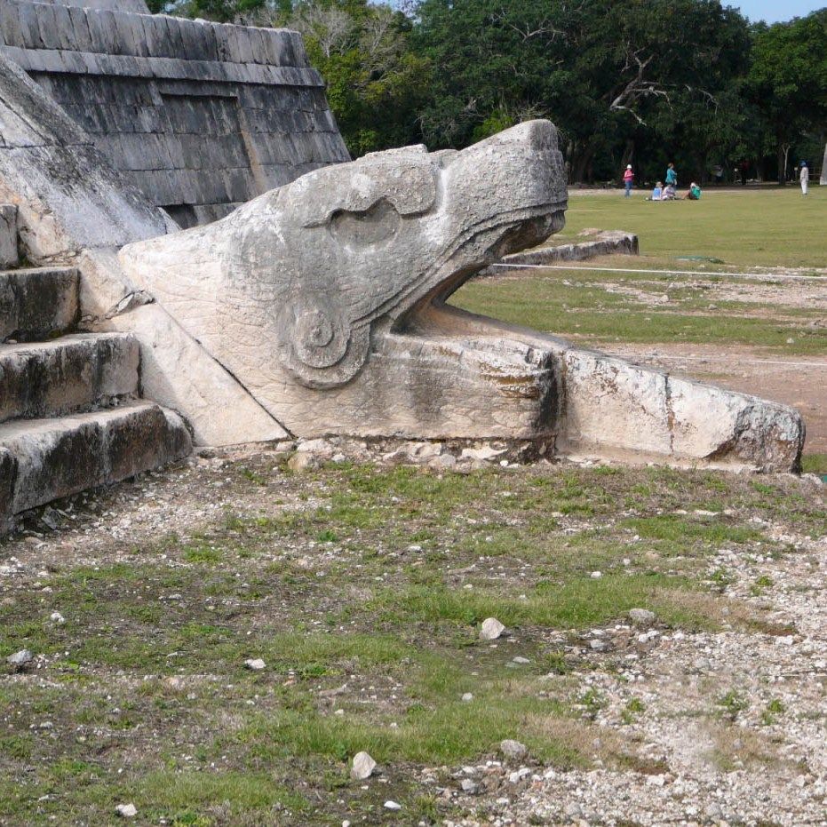
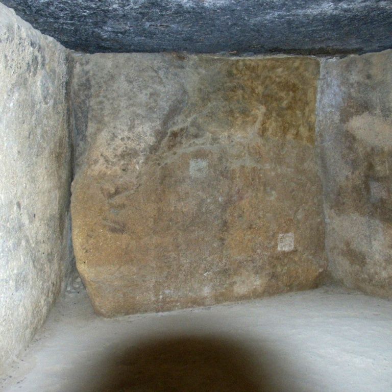
In the Seti I temple in Abydos there are also hieroglyphs that resemble the vehicle signs, but which have nothing to do with vehicles.

Helicopter
Egyptologists believe that these signs were created by modifying older signs. The signs are located at a height of 3 meters, so that the mechanical operation is not clearly visible.

Helicopter
This modern Sikorsky helicopter is an invention of the last decades. About 3,300 years ago, such helicopters were already flying around, perhaps.
An unusual sculpture has been discovered in the temple of Pharaoh Seti I that shows elements very reminiscent of modern vehicles such as airplanes and helicopters (Photos 2 to 5).
The temple of Seti is located in the center of Egypt, in Abydos on the Nile. This temple is said to have been built around 1300 BC. A section with hieroglyphs recently emerged on one of the beams that support the roof. But the curious thing is that some of these marks show a clear similarity to modern vehicles. Most striking is the helicopter, which is exactly the same as the modern 'sky crane', a cargo helicopter that can lift large objects such as containers or heavy military equipment. The other signs are slightly less clear but are reminiscent of a tank or submarine. The tail fin in combination with the design is unmistakably an element that shows that these are vehicles.
But Egyptologists are convinced that these signs were created by modifying older signs. An important clue to this are the hieroglyphs in one of the other corridors of the same temple that can easily be transformed into the vehicles mentioned.
Unfortunately, the vehicle signs are located at a height of 3 meters, making it difficult to determine the mechanical operation. And as far as we know, no technical research has been carried out in which the possible 'restoration' has been clearly established.
The mythologies all over the world are full of stories in which divine beings moved over great distances and flew through the air (see e.g.
Part-IV, Ch.3). If these signs prove to be authentic, here we see one, almost photographic, representation of those prehistoric vehicles?
Antikythera mechanism
< 65 BC
Greece
37 34' 00.05" N, 22 38' 59.90 W
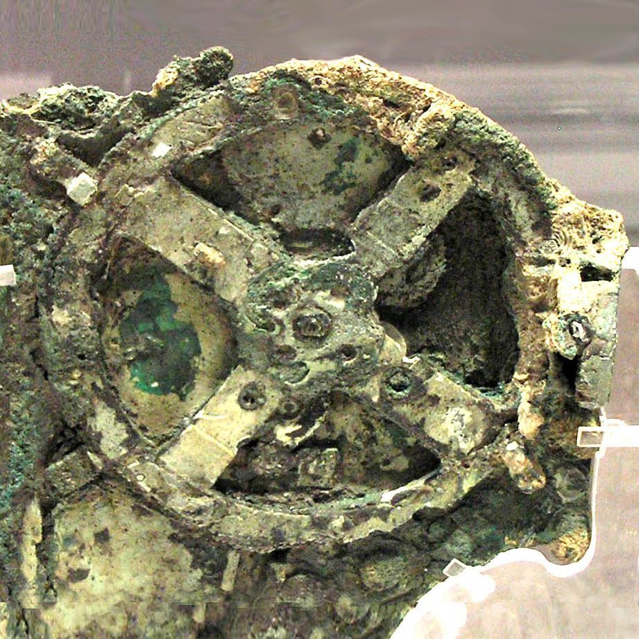
Antikythera mechanism
The Antikythera mechanism consists of a number of cogwheels

Antikythera mechanism
Only a few fragments of the clockwork now remain.

Antikythera mechanism
The Antikythera Clock is an astronomical clock.

Antikythera mechanism
A reconstruction according to the latest insights from NASA.
A very mysterious object that turns history upside down is the so-called Antikythera mechanism. It is a type of clock that is now on display in the Greek National Museum in Athens. This clock was found in 1900-1902 by sponge divers off the small island of Antikythera, which lies between Greece and Crete. The wreck where the object was found sank in 65 BC. +/- 15 years.
What makes it so mysterious is that the mechanics, and what the clock was for, is typical 18th century technology – not something from before Christ! All metal parts of the machine appear to be made from a single sheet of low-tin bronze; none of the parts are cast, or made of any other metal. From inscriptions (in Ancient Greek) on the front plate of the clock it can be deduced that the clock dates from the first century BC. It is an astronomical clock that could be used to indicate sunrise and sunset, as well as moon phases. All this means that at least 1,800 years earlier than we thought, the Greeks – or anyone who expressed themselves in Ancient Greek – had already reached the technological level that we reached three hundred years ago.
What makes it even stranger is that there is no other clock like this clock, not even a simpler clock. And that's strange because if it had been common technology in the first century BC, why weren't more examples found? It would have been a very important technology for the Greeks and Romans, but there is no indication that they had it. Since the ship carrying this clock was on its way from Rhodes and Cos and sank at Antikythera, one may assume that it was on its way to Rome. If it had arrived it would certainly have strengthened Rome's power.
So the question remains: who was able to create such a complex machine? Just like that, from scratch, without prior knowledge development?
Aramu Muru
? BC/AD?.
Peru
16 12' 51.62" W, 69 30' 21.28 W
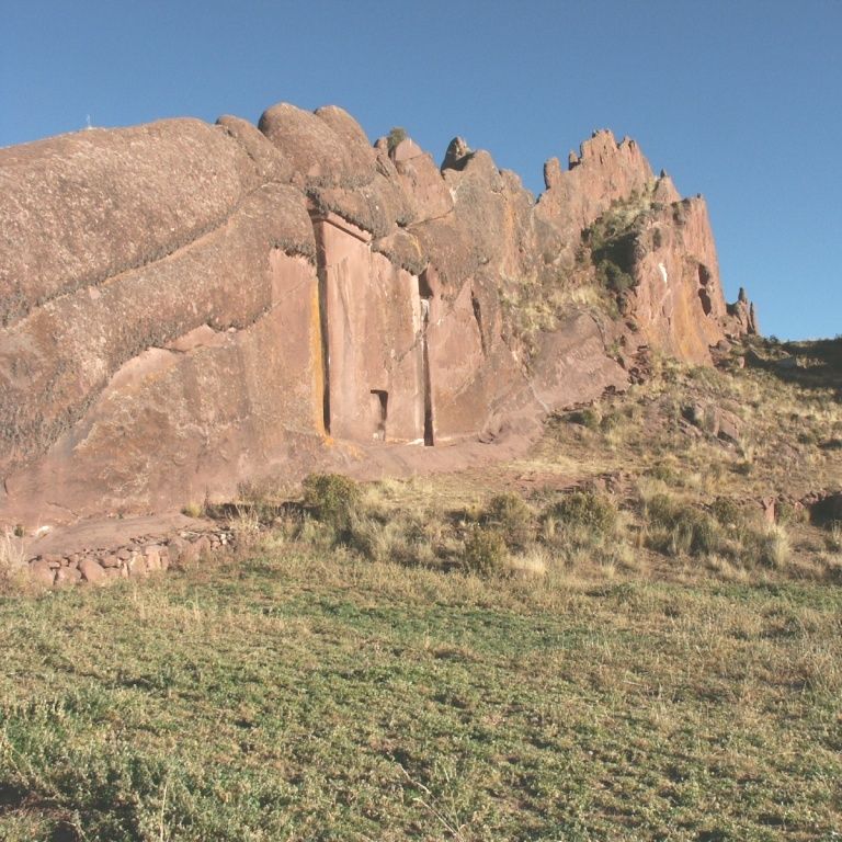
Aramu Muru
Known by the locals for centuries
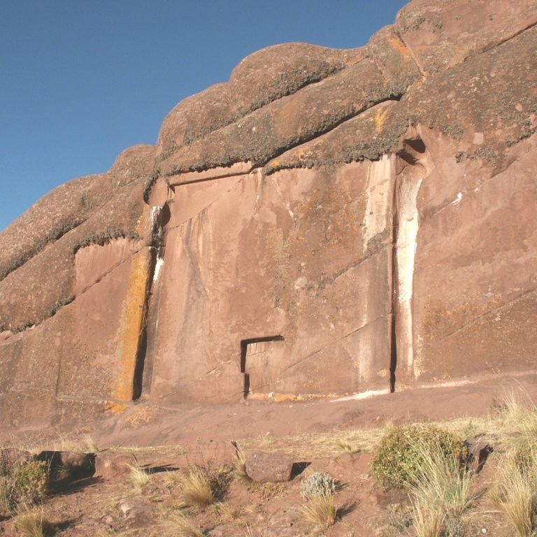
Aramu Muru
The gate to heaven
Aramu Muru
This gate would be an entrance to another dimension
Aramu Muru
The relatively soft rock is easy to work
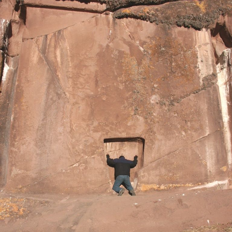
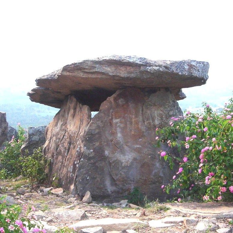
Aramu Muru is one of the strangest ancient structures in the world. It is hidden in the rugged mountainous Hayu Marca area of Peru, about 35 km from Puno on Lake Titicaca. It was only discovered recently, in 1996, although locals were of course aware of its existence. They call it the “Gateway to the Gods”, or the “Gateway to Heaven”.
Carved out of a rock, it resembles a tall facade – about 7 meters high and 7 meters wide – supporting the rock above. In the center of the facade is a small alcove – about 1.5 meters wide – which suggests it is a door for people, but there is nothing to indicate it is an actual door that can be opened.
From a technical point of view it seems nonsensical. In a strange place they created an absolutely useless sculpture in quite hard rock. If this was achieved by hammering, it was a long and very strenuous activity.
But actually it doesn't look like hammering at all. Was the rock softened first? (Part-II, Ch.11)
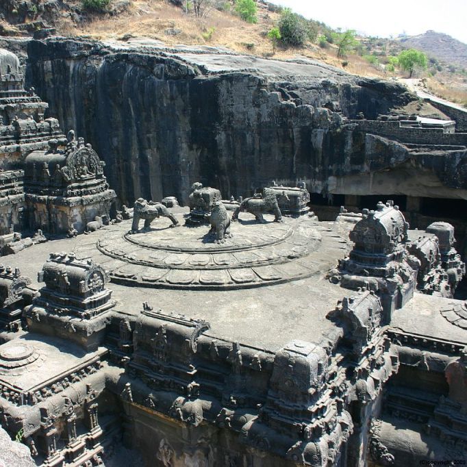
Angkor Wat
1113-1145 AD
Cambodia
13 24' 44.75" N, 103 52' 00.24" W
Angkor Wat
Angkor Wat is a huge complex with fabulous buildings

Angkor Wat
Each stone is individually designed

Angkor Wat
Many stones testify to advanced processing techniques

Angkor Wat
How to make a sharp rectangular hole?
The famous complex of Angkor Wat in Cambodia has been described in many places, so I will only focus on a single facet here. The buildings and sculptures are constructed from a type of stone called laterite: a spongy, iron-containing rock that hardens with prolonged contact with the open air, according to National Geographic Magazine of July 2009. But during a visit to Angkor Wat, Willem Fernee noticed that here and there and lay stones, sometimes unnoticed between other stones, sometimes deliberately placed, which had a completely different appearance and were reminiscent of basalt. These blocks have remarkable processing marks: round holes, rectangular holes and slots as if they have been milled out. This type of mofification can also be seen in Egypt and Peru. What does this mean? Just a coincidence? Or were there overseas contacts? And if it is basalt, we only know it in (rock) hard form, and then the question arises, who was able to process it this way and why?
Asini
1500 - 1000 BC?
Greece
37 31' 38.78" N, 22 52' 27.10" W

Asini
Fabulous wall that seems to have no purpose other than to impress
Asini
It is difficult to imagine how this wall was made with primitive tools in ancient times

Asini
This wall also seems to be useless
Asini
The stones interlock with playful ease
South of the village of Asini in the Peleponese there is a mysterious rock formation. Surrounded by the waters of the Mediterranean Sea, it appears to be a prehistoric lookout, but the megalithic constructions point to a more important purpose. From the coastal road, the first thing the visitor encounters is a seemingly pointless wall against the rock face, where all the stones fit together perfectly without cement. On the east side there is even a fifteen meter high wall in which vertical grooves have been milled, it seems. On the west side is a large cavern, unreachably high, filled with a wall constructed in the same way. Perfectly fitting stones, joined together without cement. This wall supports a higher plateau. Which high-tech contractor has been working here? (Part-I, Ch.3)
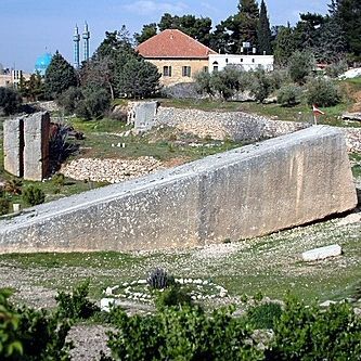
Aswan obelisk
1450 v. Chr.?
Egypt
24 04' 38.71"N, 32 53' 39.27 E
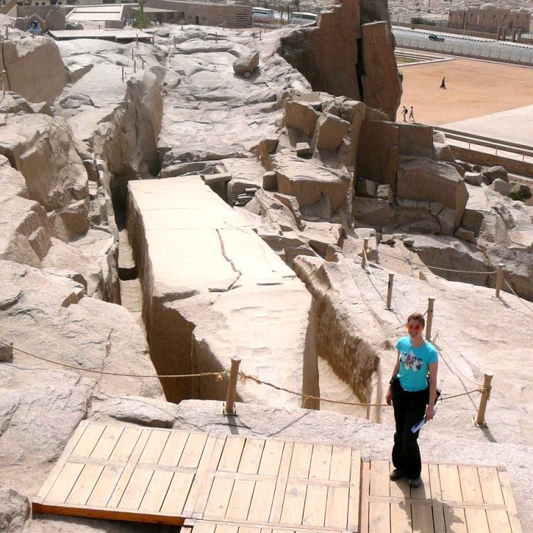
Aswan
How people ever thought to lift this colossus from the quarry is a mystery.

Aswan
You would expect the obelisk to be horizontal, but that is not the case. The 'ancient engineers' did not make it easy for themselves.

Aswan
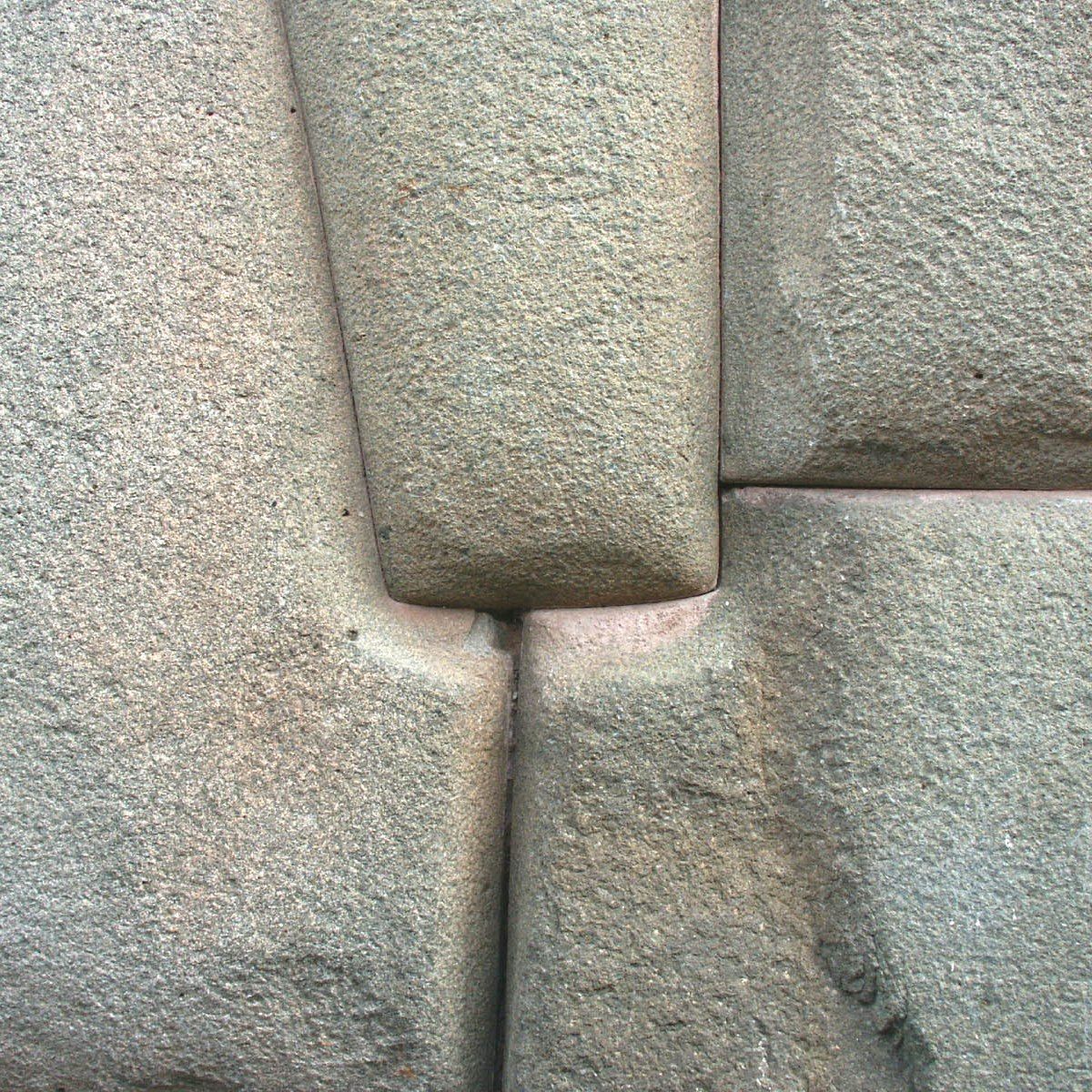
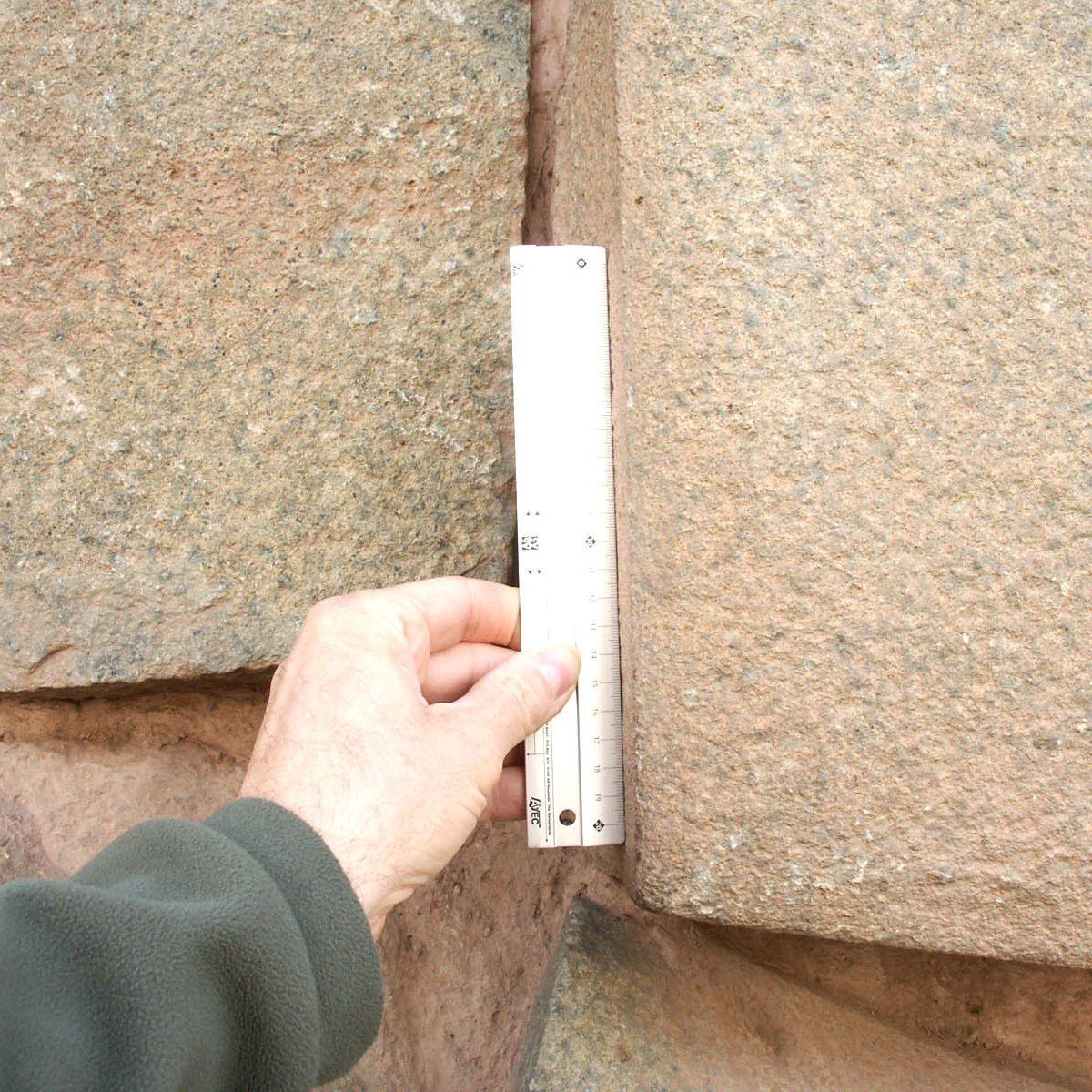
The groove along the Aswan obelisk is far too narrow for a workman to use hammers and picks properly.
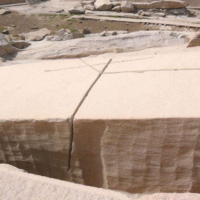
Aswan
It appears that at some point a conscious attempt was made to saw through this obelisk.
In southern Egypt, on the banks of the Nile near Aswan, lies one of the strangest mysteries of antiquity, a very old stone quarry. Amid the strange hack marks that characterize the entire area, lies an enormous obelisk. A deep groove has been cut all around so that the profile of the obelisk is clearly recognizable, but the bottom is still attached to the rock bottom. Apparently the obelisk was never finished and it is suspected that the crack that is clearly visible is the cause of this. The obelisk is located deep in the rock mass with little to no room to maneuver around it. It is therefore a mystery how this giant could have been removed from the quarry if it had already been completed undamaged. The obelisk is made of granite, one of the hardest types of stone. It is therefore difficult to imagine how workers in the narrow groove were able to carve the obelisk. Were diorite hammers used for this? Lehner once did a test with this, without results.
The strange heel marks that can be seen here amaze the visitor. These are not chop marks from a pickaxe or stone hammer. The tracks resemble the imprint of a coal shovel in the snow, but that would mean that the hard rock here was once (relatively) soft. We also find exactly the same type of tracks in Peru, for example at Ollantaytambo. Would the same technique have been used, 12,000 km apart, and 3,000 years apart?
Axum
? BC/AD?
Ethiopia
14 7' 53.62”N, 38 43' 09.68”E
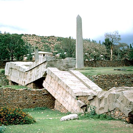
Axum
It is unknown when this obelisk fell.

Axum
Large obelisks stand close together in Axum. The largest one lies broken on the ground.

Axum
The largest standing obelisk in Axum is more than 20 meters tall.

Axum
The obelisk is manufactured with high technological precision.
Nowhere in the world are there so many monumental obelisks so close together as in Axum in Ethiopia. They are giants that are more than 20 meters long. The largest reaches 24 meters but is broken into 3 pieces on the ground. It is suspected that this 160-ton obelisk crashed while being erected. These large obelisks are gathered in a field in the town of Axum, but there are many more in the area, although they are shorter and less spectacularly decorated. The large obelisks are all designed in such a way that it looks as if there is an entrance door at the bottom, sometimes even equipped with a lever, and floors with windows. But all this is just an appearance. They are false doors and windows.
One of the giant obelisks was taken to Rome by the Italian army in 1937. After years of tug-of-war between Ethiopia and Italy, the obelisk was returned to Axum in 2005.
As far as we know, the obelisks have been there for a long time. The official story is that we have to go back to the 4th century AD, but the special thing is that these obelisks do not contain any decoration that betrays their age or founder. To give an explanation, the large obelisks – or stela as they are usually referred to – are attributed to a king, and the smaller ones to nobles. But when we look at it with a technical eye, something special stands out. The windows and doors are cut so sharply that there can be no question that these shapes were carved. This concerns nepheline syenite, a rock that resembles granite and that probably comes from the quarries located west of Axum. How were those technologically primitive kings supposed to do that at that time, even if they had had iron tools. It looks much more like these structures were applied using a plaster technique.
Another aspect is that the obelisks are placed on specially designed bunkers. Of course people now say that these are graves, but is that true? A stela standing on such a bunker is much more reminiscent of a rocket on a launching platform. Is that what the kings saw and wanted to commemorate that spectacular event? The Axum obelisks are said to be memorials on the gravestones of kings and nobles, but there is no indication that this is indeed the case. The large obelisks stand on bunkers reminiscent of launching platforms.
The sharply carved decorations could not possibly have been carved with a hammer and chisel. A plaster technique appears to have been used. It is a mystery how the extremely heavy obelisks were erected. The 160 tonner did not make it and crashed (Part-IV, Ch3)
B
Baalbek
2500 AD?
Lebanon
33 59' 56.59”N, 36 11' 58.71”E
Baalbek
This strange colossus just lies there, sunk into the sand

Baalbek
There are still a few of these colossi hidden under the sand.

Baalbek
The Romans built on top of the enormous megaliths.

Baalbek
Getting the stones into position without modern machines is impossible
Baalbek in Lebanon is one of the most mysterious places on earth. Here in the heart of Lebanon, ancient stonemasons crafted the largest and heaviest stones in the world. Later the Romans built temples on top of it. But underneath we find blocks of about 10 meters in length, 5 meters in height and 3-4 meters in depth. They weigh more than 450 tons each. Nine blocks are visible on the north side, nine on the south side and six on the west side. There are even 3 larger blocks on top of these megaliths, each weighing over 1000 tons. These are called Trilithons.
An even more famous stone lies in a quarry nearby. It is the largest of them all, weighing approximately 1200 tons. This is the largest carved stone in the world. The stone is not finished and is partly still in the ground.
The mystery is that even now there are hardly any machines capable of lifting, transporting and positioning such a block in such a limited space. And of course it is unthinkable that in ancient times this would have been done with manual force and ropes. It is clear that no human could ever have done this.
Why such megaliths were created still remains to be answered. The precise dating is also unknown. The only thing that is certain is that none of the original inhabitants, such as the Romans, ever claimed to have created these megaliths. It must therefore be hundreds, if not thousands, of years older than the Roman temples.
Baghdad battery
300 BC?
Iraq
32 23' 31.24" N, 44 20' 29.89" W

Baghdad Battery
The Baghdad battery looks like an ordinary jug
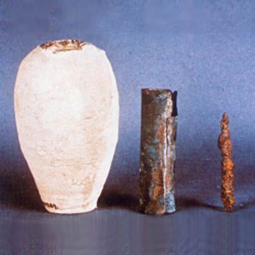
Baghdad Battery
The interior of the Baghdad battery consists of an iron rod inserted into a copper cylinder.

Baghdad Battery
It was not until 1800 that Alessandro Volta was the first to produce a battery.

Baghdad Battery
A test with a replica of the Baghdad battery produced a voltage of 1 volt.
In 1936, an unusual object was unearthed in Khuyut Rabuah near Baghdad. In an archaeological dig, a mysterious pot or vase was found that is estimated to date from a period between several hundred years BC and several hundred years AD.
The Baghdad battery is a 15 cm high jar with an asphalt lid. An iron (oxidized) rod extends in the middle and is surrounded by a 9 cm long copper cylinder with a diameter of 26 mm. When the jar is filled with some electrolyte, such as lemon juice or vinegar, it is capable of delivering an electrical voltage of about 1 volt. However, the battery is too small to provide any power. Dozens of these batteries would have to be connected together for this purpose.
The similarity with the first battery invented in 1867 by the Frenchman George Lechanché is striking. It also consisted of a pot with a negative (carbon) and a positive (zinc) electrode, separated by an electrolytic liquid.
This battery was located in the National Museum in Baghdad, but it is doubtful that it is still there after the looting in 2003.
The mysterious Balls of Costa Rica
500-1500 AD?
Costa Rica

Costa Rica
Strange orbs, large and small, littered the landscape all over Costa Rica

Costa Rica
The bulbs are now mainly used for decorative purposes

Costa Rica
Sometimes the bulbs were deep in the jungle
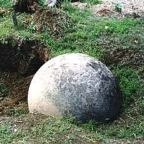
Costa Rica
No one knows who made the spheres, how and why.
“Were the gods playing golf here?”, you might ask yourself if you were on holiday in Costa Rica. Strange hard stone balls are everywhere. The whole country is littered with them. These spheres are made of hard stone, often granite, and in most cases have an almost exact spherical shape. There are small spheres, but the larger ones have a diameter of more than 2 meters and weigh several tons. Today, many bulbs have been removed from their original places and taken to parks and gardens to serve as decoration. It is therefore no longer possible to investigate the original mutual positioning in relation to each other. In addition, many spheres have been damaged by treasure hunters because it was believed that the spheres contained gold or other valuables. The purpose and necessity of these mysterious orbs is completely obscure. The way in which these spheres were made also remains a mystery. (Part-III, Ch.16)
Bimini
8000 BC?
Bahamas
25 45' 59,96" N, 79 16' 42,47" W
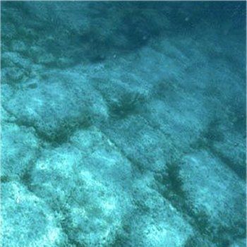
Bimini
Strange megaliths on the seabed
Bahamas
Bimini
The sea level was once much lower than it is now and this construction would have stood on dry ground.

Bimini
The stones seem to fit together perfectly

Bimini
Serious research into this mystery has never been done.
On the seabed of the Sargasso Sea off the coast of the island of Bimini in the northern Bahamas, there is a construction of enormous megaliths. The huge size immediately brings to mind the megalithic walls of Sacsayhuaman near Cusco in Peru, but here they are buried deep in the sand of the seabed. If it was indeed a similar structure that once stood on land, then it must be more than 10,000 years old because at that time the seabed of the Caribbean was much higher than it is today. Could it be a remnant of Atlantis? The stones together form a characteristic pattern that suggests that it was once a port. But there are also arguments that point towards a normal natural phenomenon.
Borsippa melted ziggorat
600 BC?
Borsippa Iraq
32 23' 30.25" N, 44 20' 30.04" W.
Borsippa
Destroyed in ancient times with an infernal fire that melted the stones

Borsippa
Destroyed and pulverized

Borsippa
Molten rock

Borsippa
The glazing is clearly visible!
Borsippa or 'Birs Numrud' is a ruined ziggurat about 15 km from the city-state of Babylon in Iraq. The remains of the ziggurat are still 47 meters high. It consists of 6 distinct terraces, each 7 meters high, each dedicated to a different planet.
In ancient times this was the site of the Ezida temple, which was dedicated to the god Marduk and previously to the god Nabu.
The southwestern hill, called Birs, is the most striking and striking ruin in all of Iraq. On top of a hill more than 30 meters high stands a pointed mass of vitrified stone, which is cleft down to the bottom, over a length of 14 meters. Over this lies a huge mass of molten stones, some as much as 5 meters in diameter, as well as single enamelled stones bearing the name of Nebuchadrezzar. twisted, bent and broken lengthwise, apparently as a result of extreme heat.
Numerous inscribed clay tablets were found during archaeological excavations and are now in the British Museum, showing that Nebuchadnezzar attempted to restore the already destroyed site.
The mystery here is the intensity of the destruction, because molten rock can only be achieved by a fire significantly higher than 1100 C, which in open air is an impossibility by normal means. We know of vitrification in open air only as a result of an atomic explosion, or as a result of the impact of a comet, but the latter can be excluded in the case of Borsippa. To give an explanation, people believe that lightning struck, but that is completely impossible.
Who or what caused this extreme heat that melted the temple? (Part-II, Ch.6)
C
Cahokia pyramid
? A.D.
United States
38 39' 17,62" N, 90 03' 32,19" W.
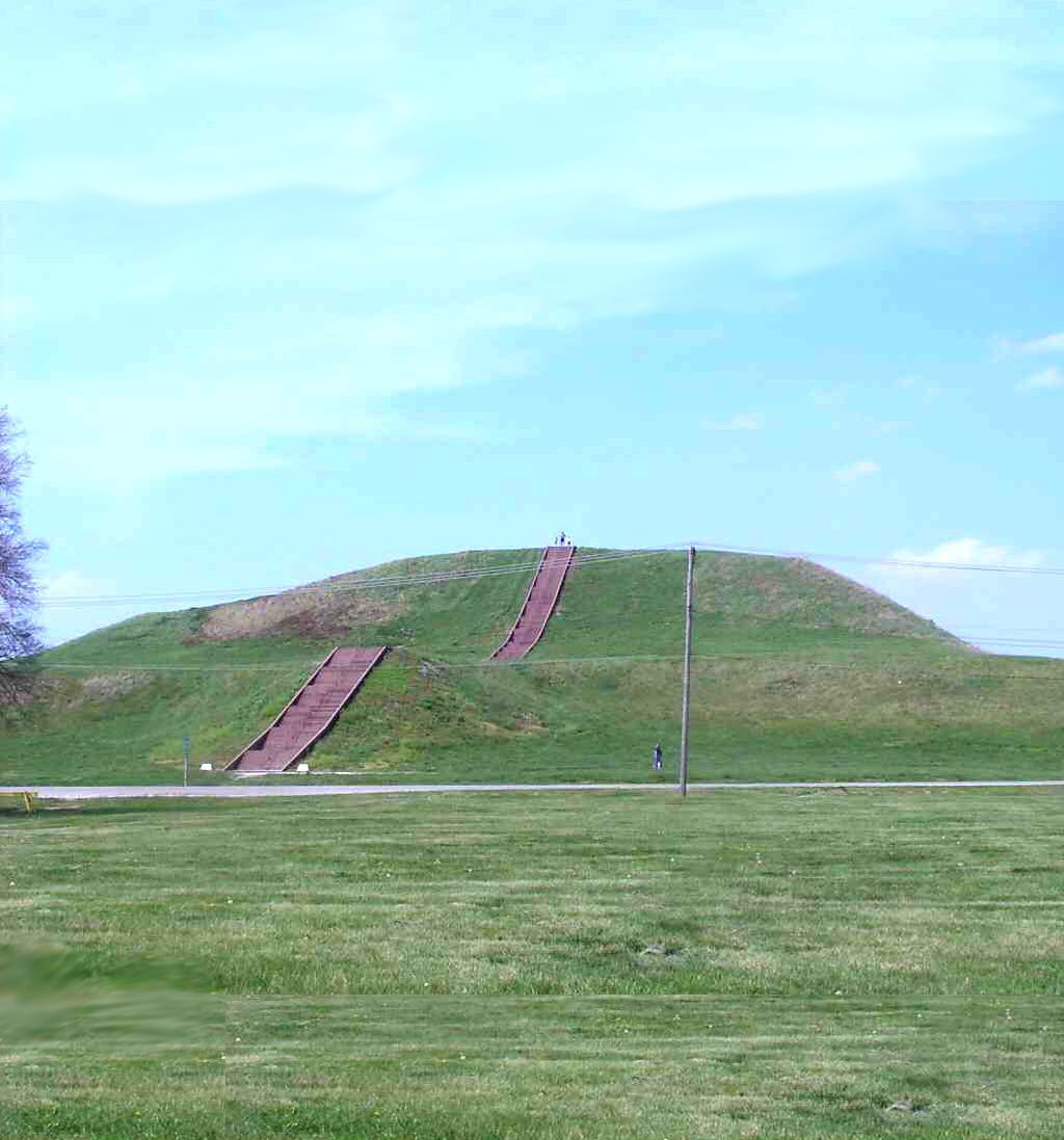
Cahokia piramide
The Cahokia Mount is one of the last remaining pyramids of the original 120.
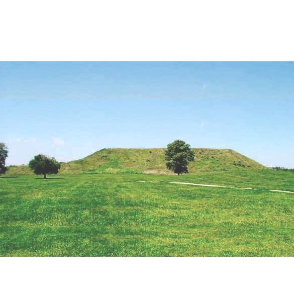
Cahokia piramide
The Cahokia Pyramid is a 'simple sand pyramid'. Yet it is the largest man-made artificial mountain.

Cahokia piramide
The Cahokia Pyramid is part of the Mississippi culture.

Cahokia piramide
The Cahokia Mount consists of 4 terraces and thus resembles the Sumerian ziggurats in construction.
Imagine that you are a chief of a tribe. You consider yourself very important. And to fulfill your obligations to your god, you convince your people that a pyramid must be built. You want to surpass all previous attempts by predecessors to build a pyramid, so this pyramid must be 290 by 255 meters and the top level - you plan to build the pyramid in four layers - will be about 28 meters.
Your people are deeply religious and follow your vision, but how do you set up such a business? How many workers are needed? How long will it take? Will it be finished before you die? Even the healthiest members of your people don't live past the age of 60. And so you start making some calculations, and to keep everything somewhat feasible you limit your idea to building a 'simple sand pyramid'. Sand can be easily transported in baskets. Each basket will hold an average of 5 liters of sand, and a workman will be able to fill about 10 baskets per minute, you think.
After a lot of headache from calculations, you are sure that the volume of your future pyramid includes 1.7 billion liters of sand. How are you going to pile up such a huge amount of sand? You are very optimistic about your chances in life, but you do not dare to count on more than 20 years to complete the pyramid. You also want to be able to enjoy it for a few years when it's finished. So that's about 10 million minutes to move the 1.7 billion liters of sand, so about 160 liters per minute, 24 hours a day, day in and day out.
Because of the dimensions of the pyramid you have already figured out that the average distance from the pyramid to the quarry will be at least 2 kilometers on average and if you place a worker every meter to pass the baskets then you will need 6000 workers in long parallel rows. But of course you also want to give them some rest and time to do other things, so you calculate a 3-shift schedule. It's not too bad that you 'only' need 19,000 men.
Piece of cake! You start immediately.
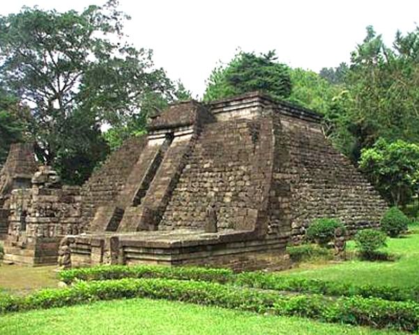
Candi Sukuh Temple
1430 AD
Indonesia
7 37'38,43" Z, 111 07' 53,60" O
Sukuh Temple
Pyramid design as in Mexico and Guatemala

Sukuh Temple
Fabulous construction technology

Sukuh Temple
A place of worship?

Sukuh Temple
No 2 stones are alike!
The Candi Sukhu pyramid (candi means temple) is located on Java in Indonesia. It is located on the slope of the Lawe volcano. It is the only pyramid in the Indonesian archipelago. Each stone of the pyramid is custom made. According to archaeologists, the pyramid was built in 1430 or thereabouts. The mysterious thing about this pyramid is that it was built according to the same architecture as the pyramids in Mexico and Guatemala. Could the same architecture have been conceived independently 20,000 km away, or did the architect visit the other side of the ocean?
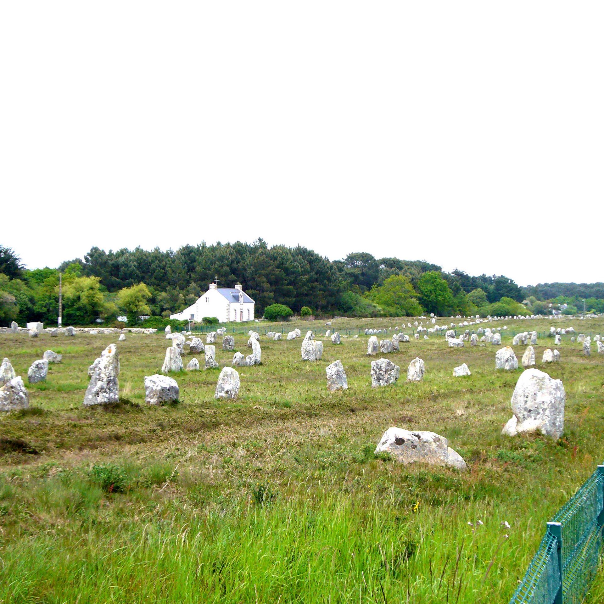
Carnac
< 6000 BC
France - Brittany
47 34’ N, 2 53’ W
Carnac
There are many menhirs, dolmens and stone circles near the town of Carnac

Carnac
The Kermario menhirs are positioned in the east-west direction.
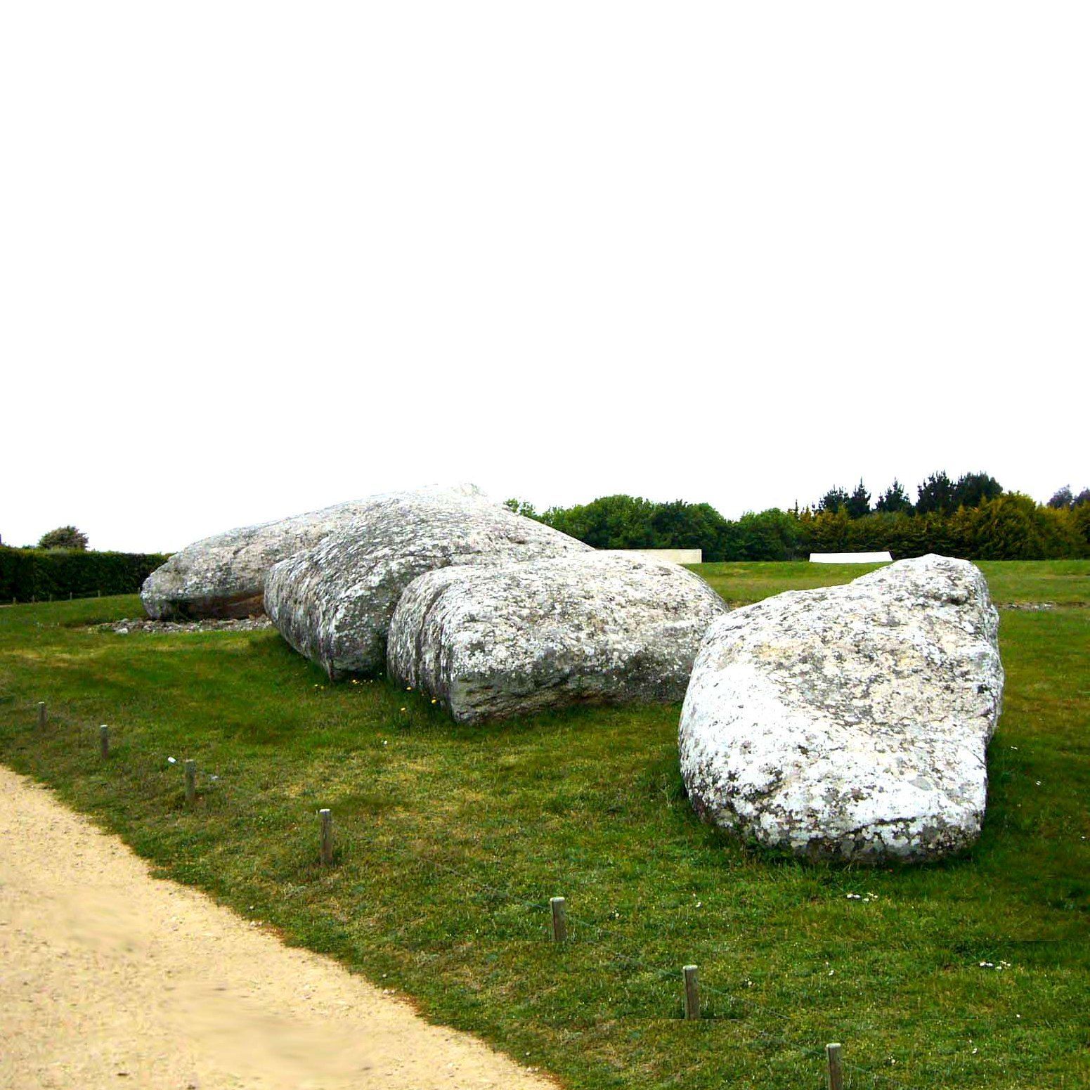
Locmariaquer
The broken menhir of Locmariaquer is the largest menhir in the world

Roch-Feutet
Some dolmens look like real bunkers
The Gulf of Mohiban, at the foot of the town of Carnac, is famous for its many megalithic remains. There are fields of menhirs (Alignement du Menec, Alignement du Kermario and the Kerlescan) that are reminiscent of modern war graves. And there are also many isolated menhirs. The largest menhir, the Grand Menhir of Locmariaquer, lies broken on the ground and weighs an estimated 350 tons. There are about 3,000 menhirs in the area, but there must have been many more in the distant past. The stone circle of Er Lannic indicates an age of at least 8,000 years.
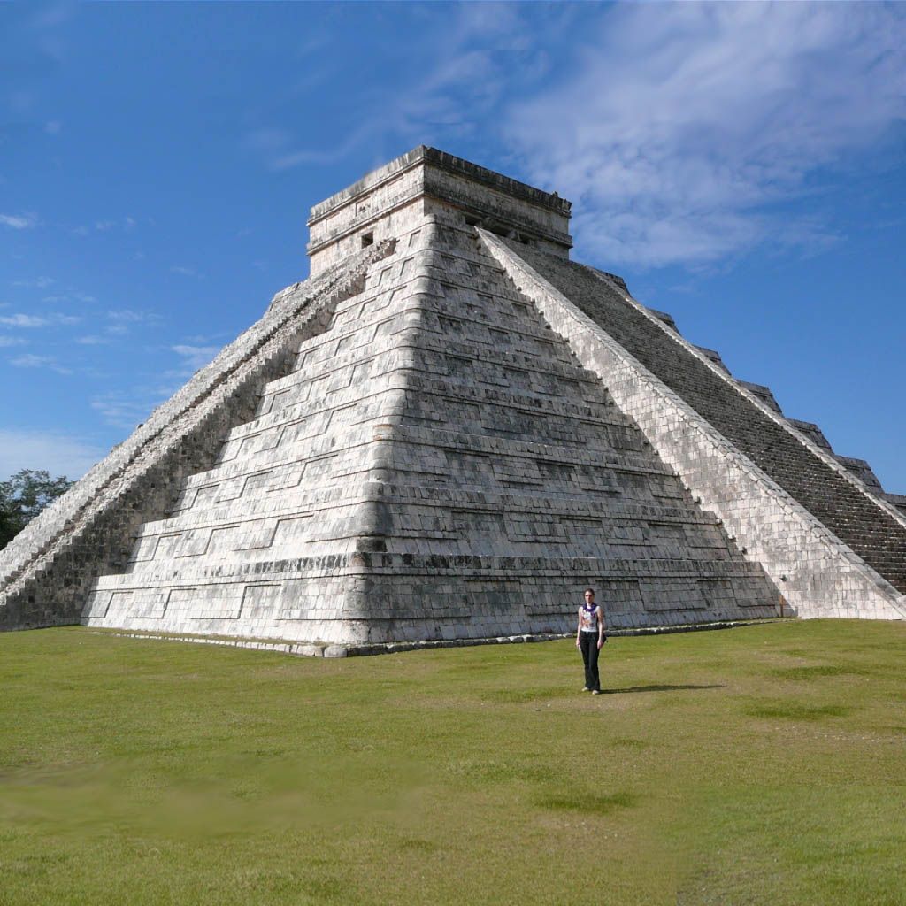
Chichin Itza
0 - 800 AD?
Mexico
20 40' 45,41" N, 89 34' 14,55" W
Chichin Itza
Mexico
The most complete Mayan city
Chichin Itza
Mexico
Fabulous construction technology
Chichin Itza
A bloodthirsty monster is waiting for you

Chichin Itza
Mexico
A temple or observatory?
Chichin Itza in Mexico is the most complete Mayan city. There are a large number of masterful buildings, of which the step pyramid is the most striking. This 30 meter high pyramid was built over another step pyramid and is said to date from the 11th century, but there are indications that this site is much older.
The construction technique is exceptional: each stone is individually designed, often with 'hooking corners' that connect with the next stone. Each terrace wall slopes backwards, which requires that each stone is modeled at exactly the right angle. It is a great mystery why this exceptional construction technique can be found in these mysterious temples, but has not been applied anywhere in practical matters such as building houses, roads or bridges.
Chavin de Huantar
500 AD?
Peru
9 35' 40.52"Z, 77 10' 37.26"

Chavin
Peru
A mysterious temple
Chavin
Peru
The architecture is very similar to that of Hagar Qim in Malta

Chavin
The gate leads nowhere

Chavin
What was the point of these sinister corridors?
Chavin de Huantar is a structure in the inland of Peru. It appears to be a kind of temple built from stones of varying sizes. The facade of the temple is made of huge blocks of stone that resemble the temples in Malta, such as Hagar Qim. The two pillars are said to be made of an unknown type of stone. Inside the temple there are narrow corridors, but the design of the temple is extremely strange.
Is Chavin de Huantar also thousands of years old? Was it designed by the same architect as in Malta?
Clapham Junction
2500 BC?
Malta
35 50' 53.40" N, 14 23' 49.69 W

Clapham Junction
This is one of the widest tracks in Clapham Junction. It appears to be a main road in the plateau.
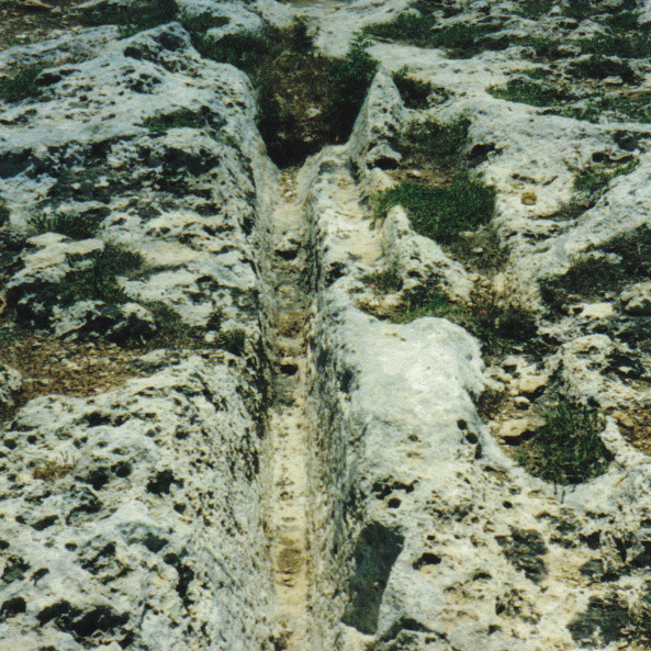
Clapham Junction
The tracks in the limestone are reminiscent of cart tracks in snow, but most tracks are not parallel.
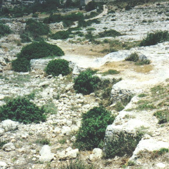
Clapham Junction
In some places the limestone plateau clearly served as a quarry

Clapham Junction
Here you can clearly see that one track merges into the other; a cart would get stuck on this
We find mysterious traces in limestone soil in various places around the world. They are several decimeters deep and slope inwards. Often there are two tracks some distance apart and therefore resemble cart tracks, but in most cases these tracks are not parallel. A cart would get stuck in it. We find this in various places on Malta, but the largest area is that of Clapham Junction, so named because it was reminiscent of the railway yard of Clapham Junction in London. But we also find such traces in Sardinia, Spain and Bolivia. Those from Bolivia, on the hill of El Fuente, have a specific shape and are made of hard rock.
It remains a mystery how these traces were created, in what time, and who made them (Part II, Ch.2).
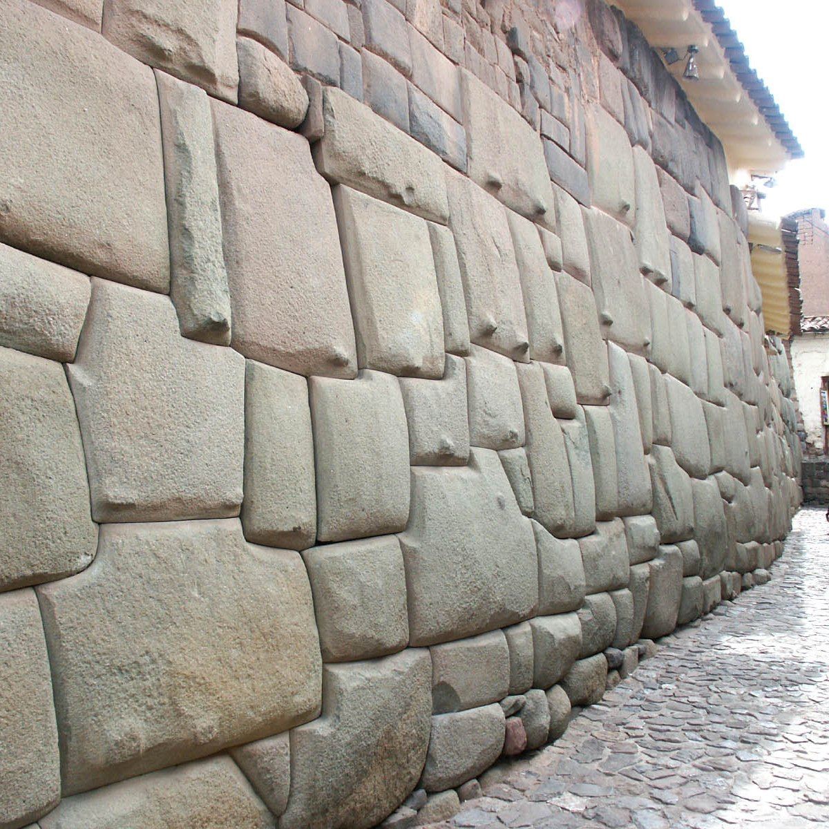
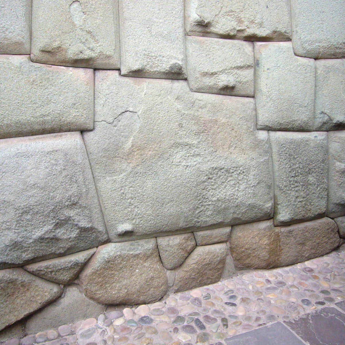
Coricancha
? BC / AD?
Peru
13°31'12.59" W, 71°58'32.51" W
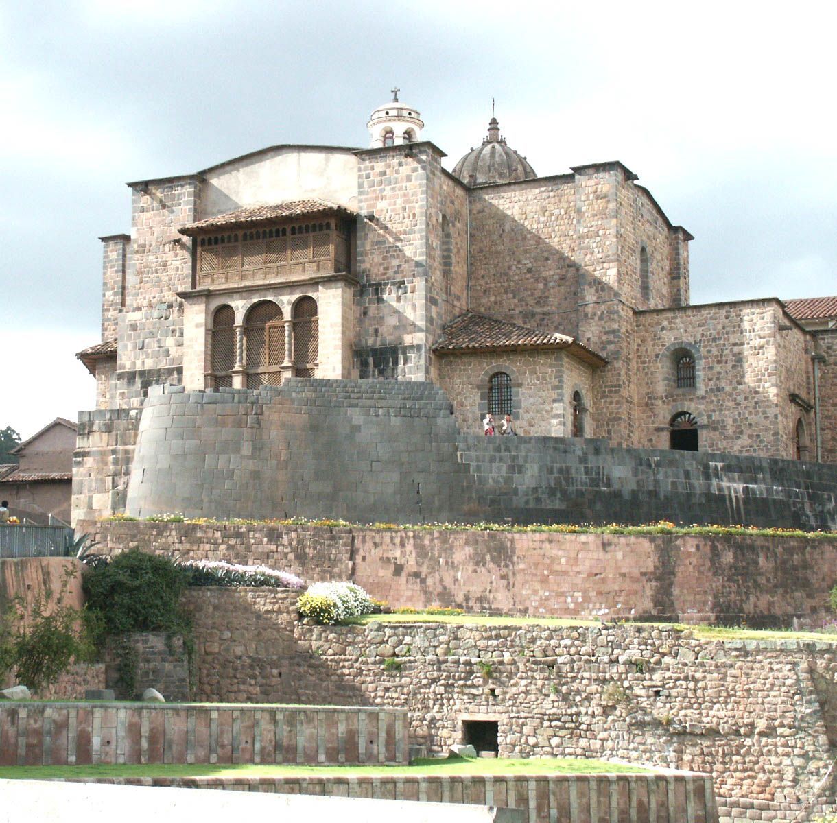
Coricancha
Cusco: The Spanish built a Catholic church on top of the Inca temple.

Coricancha
The Spanish built with cement, the Incas with precisely fitting stones.
Coricancha
These building elements are very reminiscent of modern milling and metal casting technology.

Coricancha
This filled hole amazes us.
In Cusco, Peru you can see one of the most mysterious buildings in the world, the Coricancha on the Avenida de Sol, a major road through Cusco. The structure contains a large number of mysterious technical feats, apart from the fact that the structure itself is a mysterious creation. Its purpose is shrouded in mystery, and because the Spaniards partially demolished it and built the Santo Domingo Church on it, not much remains of the original structure. But fortunately not everything has disappeared and we can still be amazed by those mysterious stone treatments that we also find here, just like in many places in Peru. Here too, there are tangible indications that the builders must have had very advanced processing methods, given the precision with which stone was processed and joined. While the Spaniards needed cement to build their church, the Incas or their predecessors got the job done without joints between the stones (Part-II, Ch.11)
D
Dolmens
?500 AD?
Korea
37 45' 44.07”N, 126 26' 26.40”E
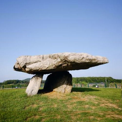
Dolmens
This dolmen is one of the largest dolmens in the world.

Dolmen
The dolmen Juk rim-ri dolmen in Korea is identical to the Poulnabrone dolmen in Ireland.

Dolmen
This type of dolmen is called the go-board type and differs from the table type because the uprights are largely sunk into the ground.

Dolmen
The uprights and cover plate seem to fit together exactly
There are hundreds of dolmens in Korea. More than 40% of the world's dolmens are in Korea. It is believed that they were founded in the period of 700 BC. to the third century BC. There are two types of dolmens. The table type consists of a large flat stone supported by three or four enormous standing stones. In the second type, the standing stones are largely sunk into the ground.
The dolmens in Korea are grouped into three groups. Most of the large dolmens are located in the Cochang area. A deck plate usually weighs hundreds of tons. The second group is located along the Jiseokgang River and is called the Hwasun area. These dolmens are largely dilapidated. The third group is on Ganghwa Island. This is where the largest of all dolmens is located...
Given the similarity with the dolmens in Ireland, England and France, this points to transatlantic contacts in antiquity, but the contradiction is that these dolmens are placed in a completely different time.
Dolmens Caucasian
2000 BC?
Russia
37 45' 44.07” N, 126 26' 26.40” W
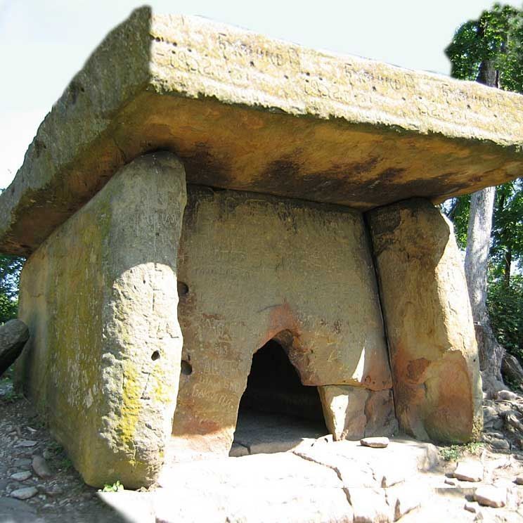
Caucasian dolmens
This dolmen looks like a small house with a veranda.
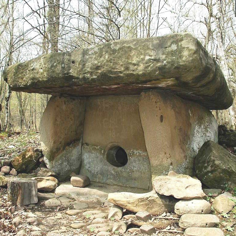
Caucasian dolmens
Most dolmens are arranged in groups of 2.
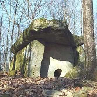
Caucasian dolmens
Some dolmens stand abandoned in a lonely place. This appears to be made with concrete technology.

Caucasian dolmens
A Caucasian dolmen often has a strange, round shape. It is difficult to imagine how this giant was built in ancient times.
There are many megalithic structures in the Caucasus Mountains. These dolmens have a different shape than those in Western Europe, Korea and India. Most have a typical rectangular shape and consist of precisely fitting, large stones. There is often a round hole in the front. These megaliths (there are more than 3,000 of them) are at least 4,000 years old. It is suspected that these dolmens were originally tombs, but there is no evidence. It is striking that the entrance is always on the south side (just like with the Dutch dolmens (Part-III, Ch.3).
E
Easter Island
1513 AD
Chili
27 10' 26.95" W, 109 24' 20.38" W
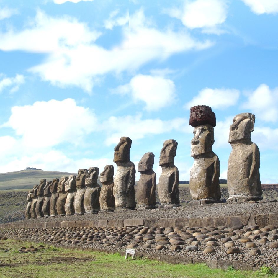
Easter Island
The images all seem to be looking at a point on the horizon as if they are waiting for something or someone.

Easter Island
There is no race in the world that bears any resemblance to the person depicted here.

Easter Island
This wall of precisely fitting stones resembles walls in Peru and is evidence that contact existed between this small island and the mainland.

Easter Island
This round stone is the navel of the world on Easter Island. Another navel is at Delphi in Greece.
Easter Island, or Rapa Nui as it is called in the local language, or Isla de Pascua in Spanish, is an island in the Pacific Ocean belonging to Chile, and has been inhabited since 400 AD. It is located 3600 km west of Chile and is one of the most isolated inhabited islands in the world. It was named after Easter because it was discovered on Easter Sunday in 1722 by the Dutchman Jacob Roggeveen. Easter Island is nothing like the other Polynesian islands. Flora and fauna are so poor that it seems impossible that civilization ever flourished here. Yet there are approximately 900 statues and 240 ahus, ceremonial platforms on which statues once stood. Many statues have sunk into the ground as if a huge landslide had buried them. Thor Heyerdahl, who visited the island in 1947 on a balsa reed boat to prove that the inhabitants originally came from South America (recently genetics has shown that the homeland of the Polynesians is in Asia), has shown that the statues (average 5 meters long and weighing 15 tons) were cut from the rock of the Rano Raraku volcano, and that hard stone hammers were used (ref. Heyerdahl)
The images all seem to be looking at a point on the horizon as if waiting for something or someone. Another mystery is the Ahu Vinapu platform, which is the only platform made of precisely fitting stones, just like the Inca buildings in South America and pyramids in Egypt. It is hard to believe that the Easter Islanders had invented the same exceptional stone technology as these ancient civilizations.
Ellora
500-1500 AD?
India
20 01' 28.72" N, 75 10' 43.64" W
Ellora
Many temples have been carved out of the rocks

Ellora
All major religions have their shrines here

Ellora
The interior is fabulously beautiful

Ellora
The monastic work was carried out by monks
In many places in the world there are mountains and hills where man has carved caves, temples and dwellings. One of the most spectacular examples are the temples of Ellora, not far from Aurangabad in the Maharashtra region of India. Dozens of temples have been carved out of the rock face on a 2 kilometer long ridge. The amount of rock removed over time is enormous. But it would have taken centuries. The first temples were built in the 7th century, and the last in the 10th century.
The geological structure of the ridge is suitable for carving out large structures because volcanic activity in ancient times created layers of diverse material on top of each other. The temples are carved into the basalt layer.
The temples belong to three different religions. The oldest group includes the Buddhist temples. The second group concerns the Brahmin temples and the youngest structures are dedicated to Jainism. It indicates that the three religions were tolerant of each other because the religions that emerged later left the older buildings untouched. Or were the buildings built under a central authority - unknown to us; an authority that also had the technology to remove such large quantities of the hard basalt and create the most beautiful shapes in the impenetrable rock?
Erdstaelle
1000 - 1500 AD
Germany

Erdställe (German, singular: Erdstal) are man-made tunnels and caves and are found in loess areas in Austria and southern Germany. They consist of systems of – often very narrow – tunnels that lead horizontally, vertically or diagonally to spaces of varying shapes and sizes. The entrance to an Erdstall is often hidden and difficult to see. Many have been found under houses, churches and wine cellars, but also many in open fields. The tunnels have the shape of a pointed arch, or have a flat ceiling, and are often no higher than 40 centimeters. The rooms are shaped like a barrel and are often no higher than 1.30 meters. Sometimes benches have been carved out, but surprisingly they are no higher than 30 cm, which is quite difficult for adults.
There is little evidence of the age of these underground systems. It is currently assumed that they were built between 1000 and 1200 AD.
There are numerous theories about their purpose and who created them, but there is no evidence. Since none of the tunnels have a second entrance, they are not very suitable as a refuge, especially since the air cannot be easily replaced.
Er Lannic
< 6000 BC
France - Brittany
47 34' 05,88"N, 2 53' 48,57" W
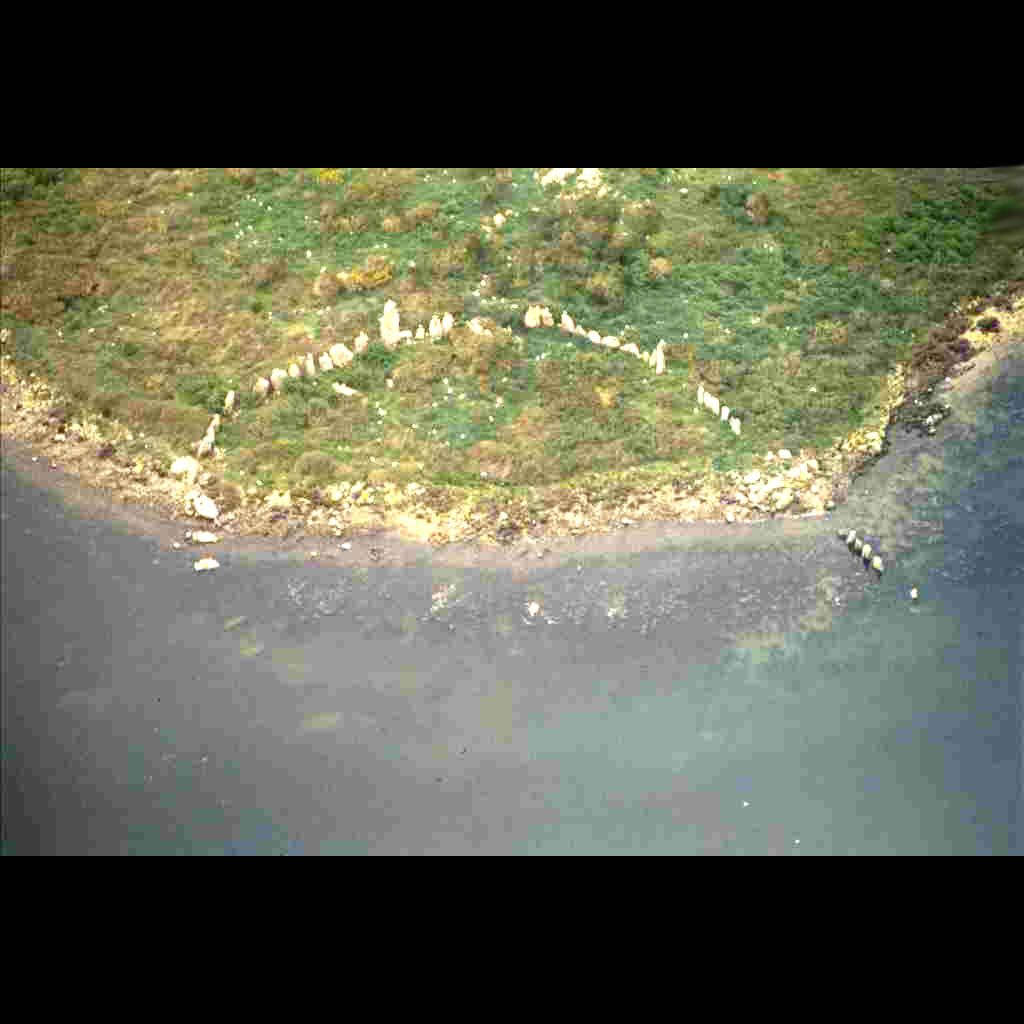
Is Lannic
The stone circle of Er Lannic is half underwater and must therefore be more than 8,000 years old.

Is Lannic
The stone circle has a diameter of approximately 65 meters

Is Lannic
It is unknown which people founded this stone circle

Is Lannic
Between 21,000 and 5,000 years ago, sea level rose by 125 meters, which is about 78 cm per century. But in 5000 years ago the sea water reached a level 1 to 2 meters higher than today.
On the small (private) island of Er Lannic there is a stone circle with a diameter of /- 65 meters that is very remarkable. Half of the circle is underwater, which proves that these megaliths are certainly more than 8,000 years old.
It is well known that 20,000 years ago the sea water was about 100 - 120 meters lower than it is now. Details of sea level rise are collected in the World Atlas of Holocene Sea Level Changes [1]. How the sea level changed in 20,000 years depends very much on local conditions because when the water rises, the earth below reacts to the increase in mass, causing the ground to sink.
And vice versa, where the ice cap melts, the ground rises due to the loss of weight. Scandinavia, for example, is still rising (by a few millimeters per year) due to the disappearance of the ice mass, and as a counterbalance the Netherlands is falling [2]. Often local conditions are difficult to understand in the absence of obvious geological factors, as for example in the Mediterranean Sea where changes in sea level are systematically small. Marseille, Genova and Trieste have not experienced any sea level rise in the last 50 years, and the cause of this is not known. The United States coast is sinking at a rate of 1.4 mm/year, amplifying the effect of overall sea level rise.
The figure shows how quickly sea level has risen in the last 20,000 years, as deduced from the many observations in the aforementioned atlas. The melting of the ice caps caused sea levels to rise by 125 meters between 21,000 and 5,000 years ago, which is about 78 cm per century. But in 5000 years ago the sea water reached a level 1 to 2 meters higher than today. There are many sightings as evidence for this mysterious event. Since global temperatures were also at a peak at that time, some of the high water levels can be attributed to atmospheric warming, but that cannot explain more than 1 meter of water. The question is therefore where the rest of the water, accounting for 1 meter worldwide, has gone.
After 5000 years ago the sea level dropped. But there are many places where sea water levels appear to rise and fall periodically in the millennia that follow, which is not yet well understood. But then, in the middle of the 19th century, before the beginning of the rise in the average temperature of the atmosphere, the sea began to rise again at a significant rate of 1.5 - 2 mm/year (15 - 20 cm/century) while previously it rose at a moderate rate of 0.3 mm/year. We do not know why this speed changed so suddenly. It could not have been a sudden melting of the ice caps of Greenland or Antarctica, at least there is no data to prove or contradict that (Part-II, Ch.7 and 8, Part-IV, Ch.6 and 7)
[1] Pirazzoli, P.A., “World atlas of Holocene sea level changes”, Elsevier, Amsterdam, 1991
[2] Douglas, B.C., et al., "Sea level rise”, Academic Press, New York, 2001
Externsteine
1500-1000 BC?
Germany
51 52'08.22” N, 8 55' 01.96” W
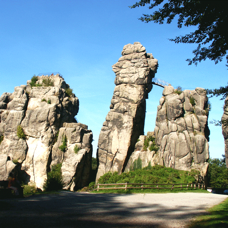
External stones
On top of the rock there is a sun-oriented temple.
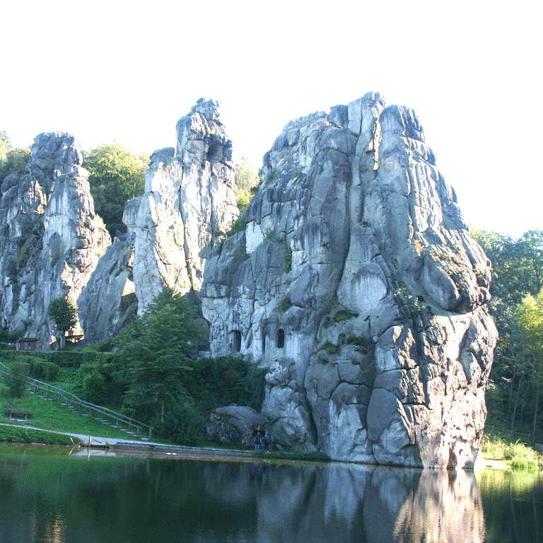
External stones
The rocks are torn apart and tilted forward.
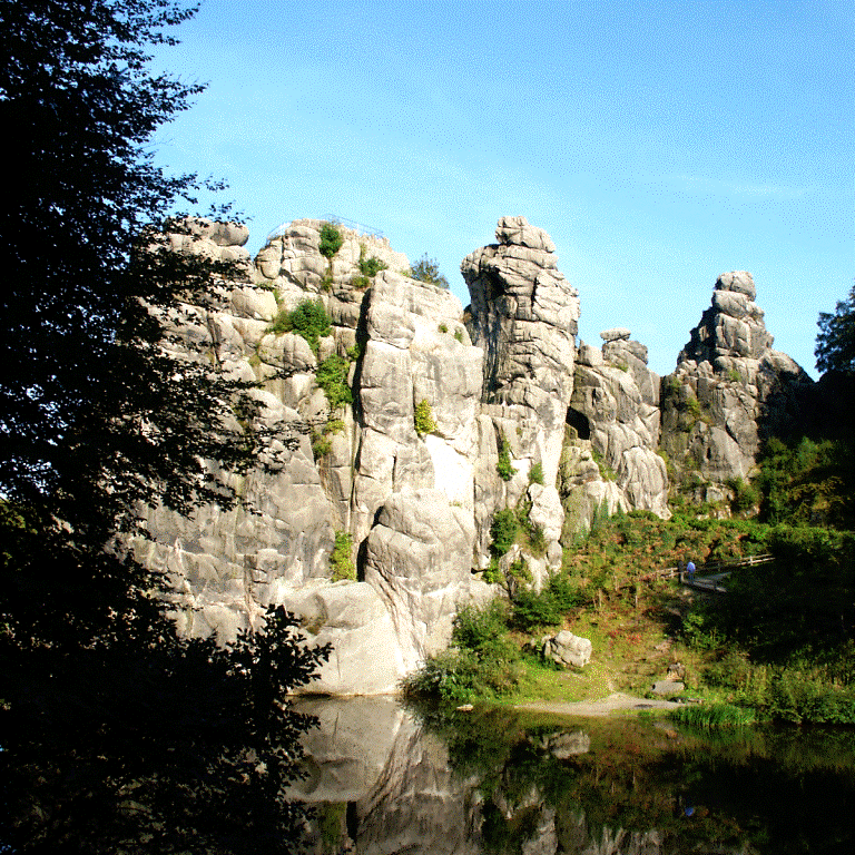
External stones
The high rocks are partly in the water.
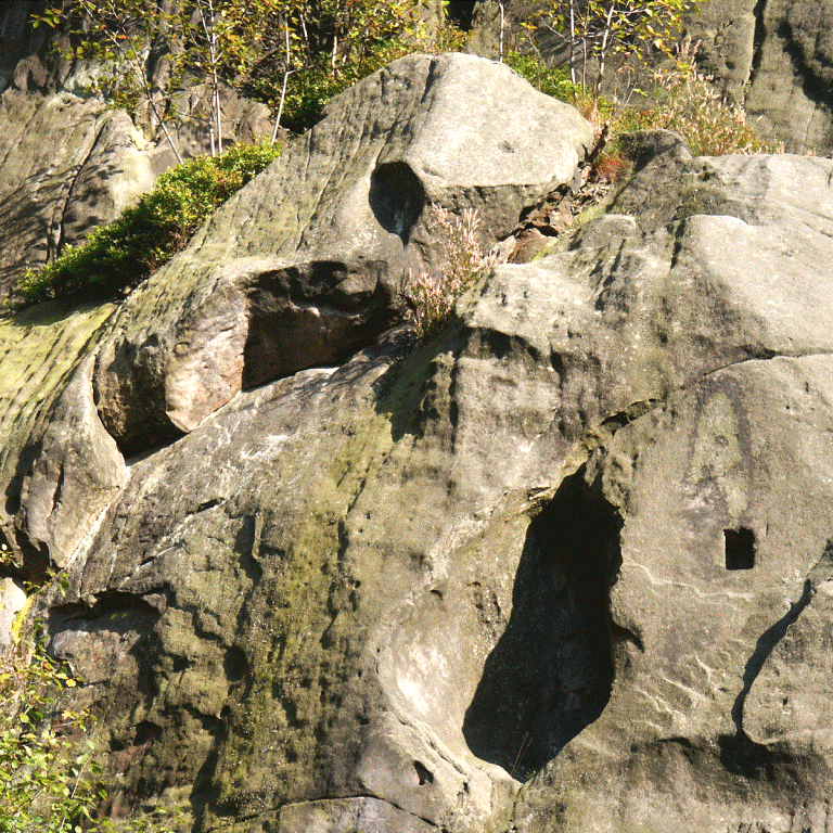
External stones
The traces of machining are difficult to date, but they certainly go back to the Stone Age.
Externsteine is located in the woods near Paderborn in central Germany. It is a sandstone rock formation consisting of a number of high columns that are partly in the water. The rock formation appears to be a freak of nature, although such rock formations are almost non-existent in the wider area. The rock formation has been largely modified by humans. Traces of machining reveal that the complex has been used for ceremonial purposes for centuries. The carved temple on top of one of the columns is the best proof of this. A round opening in the temple wall is said to play a role in the earliest rays of the sun at the solstice.
On the day of the summer and winter solstice, Externsteine attracts many visitors (Part-II, Ch.6).
G
Ggiantija
3600-3000 BC?
Malta
36 02' 49.00" N, 14 16' 07.46" W.

Gauntia
Malta
Gauntia
Malta

giant
Malta

Gauntia
Malta
The Ggantija Temple is located on Malta's second island, Gozo, and is the largest megalithic temple in Malta. As with the other temples of Malta, the Hagar Qim, Mnajdra and Tarxien, the question is whether this 'temple' served as a place of worship or whether it served another purpose. The fact that it is located on such a small island is strange in itself: such a large construction suggests that there was a large population in the area, not only to build it but also to serve as a temple.
The temple was built in 3600 BC. - 3000 BC dated, but a big question mark can be placed about this because these dates have never been scientifically determined.
It's just not right. Small island, no people around, a fortress-like structure. Who were the prehistoric engineers? (Part-II, Ch.2)
Golden airplanes
? BC/AD?
Columbia
-

Golden airplanes
These mysterious planes can be admired in the Ubersee Museum in Bremen
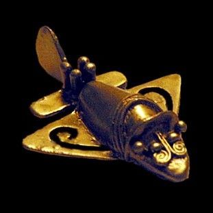
Golden airplanes
Are they really airplanes or should they represent something else?

Golden airplanes
Pure gold

Golden airplanes
You can also see a bird or flying fish in it
Many mythologies talk about flying machines. These were used by “gods” to fight their mutual wars. But beyond these mythologies, is there any indication that such flying machines ever existed in ancient times? The positive answer is given by museums in Germany (In the 'Goldkammer' of the Uebersee Museum in Bremen and the 'Goldkammer' of the Volkerkundemuseum Dahlem in Berlin) and in Colombia (Museo del Oro Bogota). They have small gold objects in their collection that look exactly like modern airplanes. These museums believe that they are amorphous figures that represent flying fish and birds.
These objects were found among the Tolima Indians in Colombia and are at least 1,500 years old, although the actual age can never be determined because the original location is no longer known.
The gold objects have a typical shape: triangular delta wings, blunt nose, high tail fin and they are approximately 8 – 12 cm long. The wings are attached to the underside of the fuselage, which effectively rules out the possibility that they represent flying animals.
Great Pyramid of Cheops
? 2500 BC?
Egypt, Giza
29 58' 45.11” N, 31 08' 03.65” W
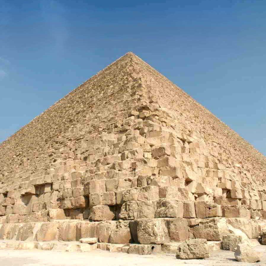
Great pyramid
The Great Pyramid consists of more than 2 million blocks of limestone.

Great Pyramid
The enigmatic 'sarcophagus' is located in the King's Chamber.
Great Pyramid
The so-called “air shafts” are said to have allowed the pharaoh's soul to travel to the constellation Orion.

Great Pyramid
The Grand Gallery is a mysterious but sublime masterpiece.
The Great Pyramid in Egypt is a true mystery. All textbooks state that “the pyramid of Cheops (Khufu) – built during his 20-year reign by thousands of workers, equipped with ropes and copper tools – and served as a tomb for Cheops”
However,
o there is no indication or remains that indicate that the pyramid ever served as a tomb
o there is no evidence that Cheops built the pyramid. The signs in the rooms above the King's Chamber that refer to his name had been placed there fraudulently by the discoverer of these rooms, H. Vyse.
o twenty years to build this pyramid consisting of more than 2 million blocks requires a placement rate of 1 block every 5 minutes, continuously. This means extremely sophisticated logistics capabilities that have never been equaled since.
o essential parts of the pyramid are made of granite, a very hard material that certainly cannot be worked with copper tools
o advanced cylinder drilling techniques were applied in hard rock. Clear evidence for this was already provided by intensive research by WF Petrie in 1883, Petrie.
o the rooms above the King's Chamber are not 'relief rooms' as is often claimed. There is no technical analysis to substantiate this view. Furthermore, lower rooms – ie the Queen's Chamber, and the King's Chamber in the Second Pyramid – do not have such 'defecation chambers'.
o The King's Chamber has suffered greatly from destructive forces, causing the walls to dislocate. The restoration material shows that the restoration took place in ancient times. What caused the disruption (which only affected the King's Chamber, but not the Queen's Chamber and the underground chamber) remains a mystery. From an engineering point of view, resonance in the King's Chamber seems a logical explanation.
o formal scientific research has shown that this pyramid is at least 300 years older than the time when Pharaoh Cheops is assumed to have lived.
o And maybe the pyramid was some kind of machine
H
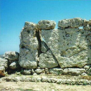
Hagar Qim
? 2500 v. Chr.
Malta
35 49' 39.82" N, 14 26' 32.49" W

Hagar Qim
The main entrance is still intact. The huge blocks on the left are heavily eroded

Hagar Qim
The upright stones appear to have suffered more erosion than the stones above them.

Hagar Qim
The curving wall suggests that the temple once had a roof made of the stones that now lie on the ground.

Hagar Qim
The upright stones clearly reveal the 'precisely fitting stone technology'
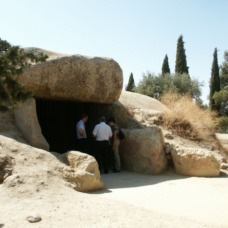
The Hagar Qim Temple is located on the main island of Malta and is one of the best preserved megalithic temples in Malta. As with the other temples of Malta, Ggantija, Mnajdra and Tarxien, the question is whether this 'temple' served as a place of worship or whether it served another purpose.
The architecture is characteristic of Malta: a shape reminiscent of a trefoil with walls consisting of two parallel walls at a distance of 2 meters. The space between the two walls is filled with stones and sand. It is a sturdy wall that has been there for several millennia. The length to width ratio is roughly 40 by 30 meters and some of the megalithic blocks are more than 6 meters high. It is unclear whether there was ever a roof on top. The walls do not seem to be made to support megalithic roof slabs.
Long ago, in 1839, the temple was excavated. The temple was built in the period 3300 BC - 2500 BC. dated, but these dates have never been scientifically determined.
There are many question marks. Why is this temple here, on an island, far from civilization? Or was the island not an island at all in ancient times, but connected to the mainland? And who cut and transported the enormous stones? (Part-II, Ch.2)
Hatunrumiyoc
? BC/AD?
Peru - Cusco
13°30'57.38" Z, 71°58'34.06" W
Hatunrumiyoc
This fabulous wall in Hatunrumiyoc Street in Cusco is still completely intact.
Hatunrumiyoc
This 12-sided stone is world famous.
Hatunrumiyoc
Try getting a razor blade in here.
Hatunrumiyoc
Is it possible to make stones as flat as shown here, without modern tools?
The remains of a mysterious Inca building are located in Cusco, Peru. It is located just northeast of the basilica on Hatunrumiyoc Street. It was originally the residence of the Inca, but the Spaniards confiscated it, largely demolished it and built a palace for the bishop. Now it serves as a museum. Fortunately, important parts of the original walls have been preserved, and these show what the iNcas or their predecessors were capable of in terms of construction. They did not have to invent cement, because these walls show that perfect walls could be built by shaping the stones in such a way that no pin can get between them. It's still a mystery how they managed to do that. The colored plaster layer suggests that one was able to soften the rock-hard material (here diorite) and reapply it with a color added (Part-II, Ch.11).
Hellenikon
3600-3000 BC?
Greece
37 34' 00.05" N, 22 38' 59.90" W
Hellenikon
This remarkable pyramid consists of individually shaped trapezoidal stones.

Hellenikon
Originally this pyramid had a pointed shape

Hellenikon
The pyramid overlooks the bay of Argos
Hellenikon
How were these stones constructed this way in ancient times?
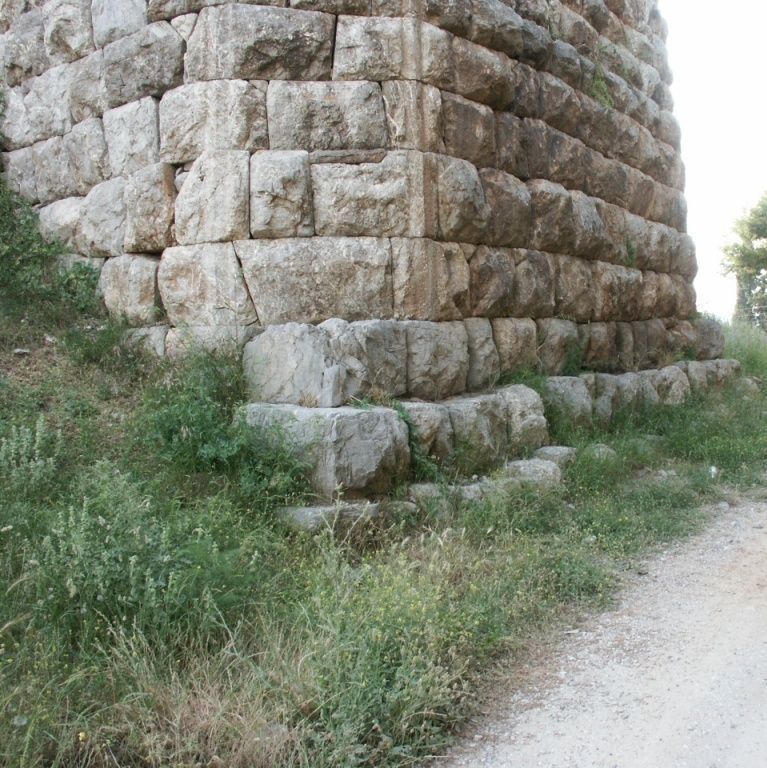
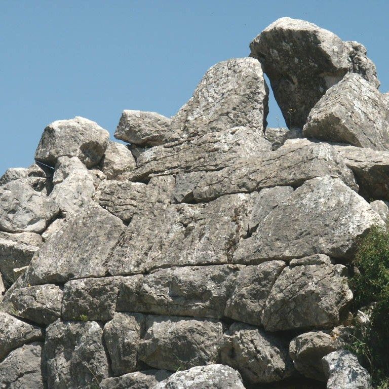
The pyramids of Egypt and America are world famous, but few know that there are also a number of pyramids in Greece, although they are very small and often little more than ruins remain. The most famous and best preserved pyramid is that of Hellenikon. This is located about 6 km southwest of Argos in the Peleponese.
There is a fence around the pyramid, which has largely collapsed. The stones are made of limestone and probably come from the immediate area. The pyramid has a strange shape and is open on one side. Each of the stones has an individual characteristic shape as they are tapered, trapezoidal and polygonal, and fit together exactly without cement.
It is unknown what this pyramid was for. Tourists may believe that it was a shelter for soldiers who had to guard the road from Argos to Tegea, but there is no evidence to support that claim. Also who built this pyramid and when we can only guess (Part-I, Ch.3)
Hunebeds
2500 BC?
The Netherlands
52 55'48.87“ N, 6 47'50.8“ W
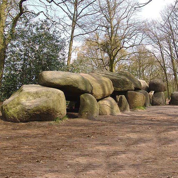
Dolmens
Borger's dolmen D27 is the largest of the 54 remaining dolmens. There are 28 standing stones and 9 covering stones.a

Dolmens
The cover plates (here Borger) are flat on the underside. How are the stones flattened?

Dolmens
Dolmen D8 near Kniphorst. The standing stones are cleaved.

Dolmens
The dolmen D50 of Noord-Sleen is impressive because of the enormous covering slabs. One can only guess how the builders got these giants into place.
A mystery that has puzzled scientists for centuries are the 54 so-called “Hunebeds” in the northeast of the Netherlands [Bom 1978, Klok 1979, Giffen 1925]. There are dolmen-like constructions on the higher parts of the landscape. But dolmens usually consist of a few standing stones with one covering slab; a dolmen has an average of 10 standing stones and is covered with a number of large boulders. The standing stones are flat on the inside, just like the underside of the cover plates. They appear to be split stones because often the flat side mirrors that of a nearby stone. Who ever built these megalithic constructions, how, and for what purpose is completely unknown.
An unproven claim is that they once served as graves, but another explanation may be that they were fallout shelters against catastrophic disaster. The name "hunebed" may refer to the Huns, but they have nothing to do with these structures. Rather, it refers to the old term 'huynen' which would mean giants - oriented along the east-west direction, with the entrance on the south side. It is unknown whether there is a specific reason for this orientation. There were once hundreds of dolmens, even across the border in Germany, but they were demolished over time to serve as building material for churches, roads and sea walls. Today they are protected by law, although no measures have been taken to protect them from vandalism.
The largest dolmen is in Borger, which consists of 28 standing stones and 9 covering stones, also reconstructed. Because there are indications that a dolmen may have been covered with sand, one dolmen has been reconstructed as such, the so-called Papenless church.
The Hypogeum
3000 BC.
Malta
35 52' 11.69"N, 14 30' 22.85"E

The hypogeum
Malta: The entrance to the Hypogeum hal Saflieni is a simple door in a simple wall in a simple suburb of Valetta

The hypogeum
The Hypogeum is a temple 3 floors underground

The hypogeum
You enter the Hypogeum via a double airlock.
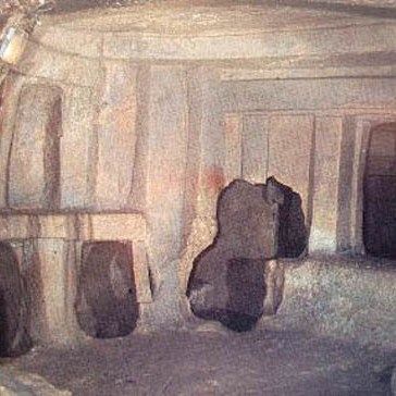
The hypogeum
Carved out with a preconceived plan
The Hypogeum Hal Saflieni was discovered by chance. While building houses on the outskirts of Valetta, Malta, someone suddenly fell into a hole in the ground. Later the site was excavated and what came to light is unique: a kind of underground temple, as if it were built with megalithic blocks, but that's not the case: instead it was carved out of the ground.
It has 3 levels and dates from prehistory, that is, it is thought to date from about 3000 BC.
Just imagine constructing this multi-layered underground temple, without hard metal tools, and without light. Dig into the ground in the dark, or perhaps with oil lamps. What could be the reason for this?
Malta is a small island, so whoever lived here at that time must have had a special reason to do so. If it was a temple for worship, then (many) people must have lived in the area to attend the services. But here on Malta, such a small island? Even if one assumes that at that time the island was connected to the mainland of Italy, it is still 'the end of the world'.
There is no second Hypogeum in the world – it is unique. An underground temple would not be a very comfortable place for priests and visitors to stay for longer periods due to darkness, lack of fresh air and rainwater flowing in. The only reason one can imagine is that it was not a temple but a shelter, and the person living down there could not stand the sunlight and UV/IR radiation. (Part-II, Ch.2).
K
Knossos
2000 BC
Crete
35 17' 52.40” N 25 09' 47.20” W

Knossos
Part of the ancient palace of Knossos has been restored, but no one knows what it really looked like.

Knossos
Some of the buildings consist of megaliths.
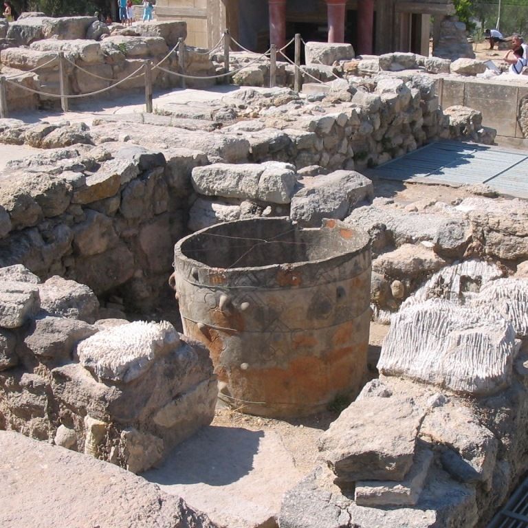
Knossos
It is said that this pot was carved from stone

Knossos
It is unknown why these barrels were placed in the semi-underground pits
The ancient complex of Knossos on Crete was discovered relatively late, in 1878. Before then, the ruins were used by locals as a site for building materials. But upon further investigation it turned out that this was a very old palace complex dating from at least 2000 BC. The legendary king Minos is said to have lived here, but hard evidence is of course lacking. The Minoan civilization fell, perhaps as a result of the gigantic volcanic eruption of Thera (Santorini) in 1390 BC.
Some of the palaces have been restored, but this restoration says little about what it originally looked like because there was little material left. But interestingly, the ruins contain a number of mysterious things, for those who pay attention. Firstly, there are the enormous blocks of stone that, when flattened, form a wall without cement. The Minoan palace was built on a much older structure. Then, the complex has an advanced water drainage and supply system similar to that in Machu Picchu, which made cool water available in the palace. And just like in the Tarxien temple complex on Malta, we find stone pots here, next to earthenware jars, the function of which is unclear
L
Lalibela
1200 AD
Ethiopia
12 01' 53.83" N, 39 02' 28.15" W.

Lalibela
The church does not rise above the ground

Lalibela
Each church is in the shape of a cross
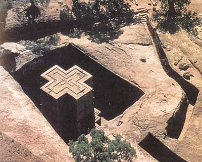
Lalibela
Many cubic meters of sand and rock were excavated to achieve this

Lalibela
Carved out with a preconceived plan
In Ethiopia, near the town of Lalibela, there are the strangest churches in the world. They are completely carved out of the rock, deep into the ground and are completely hidden from view from a distance. This concerns about 12 churches and chapels, four of which are completely detached. The most famous are Bet Medhane, Bet Maryam and Bet Giorgis. Local legends report that these churches were built by King Lalibel on direct orders from God. He was helped by angels and completed the job in less than 24 years. All this is said to have taken place around 1200 AD. B.C.
Lore Lindu
Indonesia - Sulawesi
? BC / AD?
1 41’ 29.63” Z, 120 12’ 47.89” O
Lore Lindu
This Palindo statue would not look out of place in a modern art gallery.

Lore Lindu
Some images resemble the pigmy tarsian animal that was thought to be extinct.

Lore Lindu
As with the statues in Tiahuanaco, the hands rest on the stomach.

Lore Lindu
The stone pots have a lid.
In a remote corner of the world, in a difficult to access area on the island of Sulawesi in Indonesia, lies the mysterious Lora Lindu National Park. It is a nature reserve under UNESCO protection because of its exceptional flora and fauna. But it is also home to a large number of mysterious megaliths. No one knows who the creators were or how old they are. Estimates range from hundreds to thousands of years.
Some images are reminiscent of the moai on Easter Island, but others are more reminiscent of the newly discovered primate pigmy tarsian. The Palindo statue in the Brada Valley could pass for modern art. Until recently, this statue was buried up to the waist, and it is still unknown how deep it is in the ground.
The Lore Lindu park is a tropical area where the soil is soft due to the rich vegetation. This makes it virtually impossible to move heavy megaliths; it immediately sinks into the ground. Another strange mystery is the stone pots of Kalamba in the Besea Valley. These are very similar to the stone pots in Laos. Where these pots come from, who made them, when and what they were used for remains a mystery.
M
Machu Picchu
Peru
? BC / AD?
37 01' 26.37" N, 04 32' 46.89" W
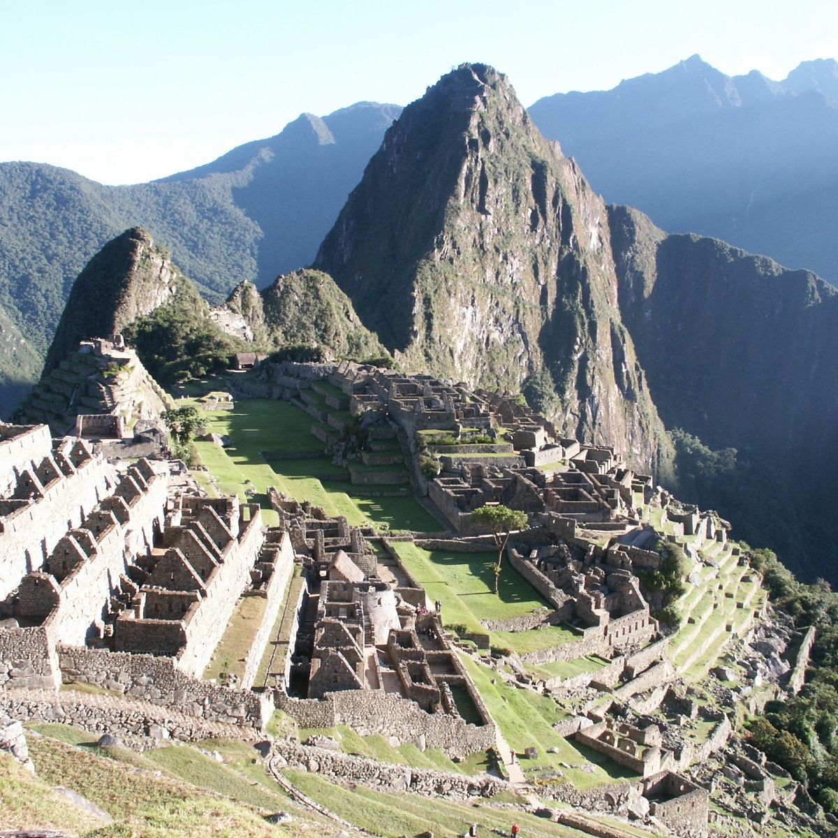
Machu Picchu
Machu Picchu is hidden in the jungles of Peru

Machu Picchu
The Sun Temple in the center of Machu Picchu surrounds a remarkable black rock mass.

Machu Picchu
The usefulness and necessity of this mysterious Intihuatana is unknown

Machu Picchu
The construction reveals an advanced concrete casting technique
High in the Andes, north of the city of Cusco, hidden on a sharp mountain top lies the mysterious ancient city of Machu Picchu. The Incas lived there but when it was built is unknown. Due to the limited space, only about a thousand people could have lived there.
The city remained beyond the reach of the Spanish and was only discovered relatively recently, in 1911 (by the American researcher Bingham). The city has houses, palaces, terraces and squares. The center is the small square with the Intihuatana stone, but we can only guess what it was for. Another remarkable structure is the so-called Sun Temple, which is actually a wall enclosing a mysterious rough rock base. It is not known why this rock is so important that it is surrounded by a beautifully carved, semi-enclosed wall. If Machu Picchu is mysterious because of its location in the Andes Mountains, it is especially mysterious because of its unparalleled stone technology. Here we find precisely fitting hard rock, stones with multiple interlocking surfaces and rock that has been manipulated as if it were soft butter. And all this was accomplished in an inaccessible place, at an uncomfortable height.
So the big question is: Who was able to implement such advanced technology? How did they do this? And why here? (Part-II, Ch. 11)
Madain Saleh
Saudi Arabia
400 AD?
26 47' 30" N, 37 57' 30" W

Madain Saleh
Why was this beautiful structure carved in a barren desert?
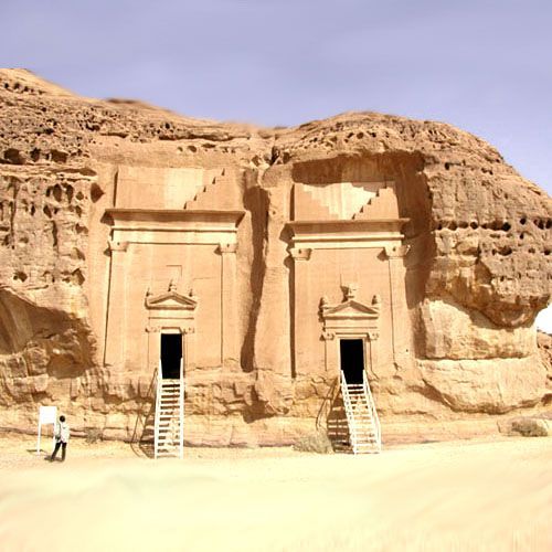
Madain Saleh
Would Madain Saleh have been under water in the past because the street is now lower?

Madain Saleh
To create these structures, people cut from top to bottom

Madain Saleh
After two thousand years, the temples still look pristine
Madain Saleh is, just like Petra, an extremely remarkable city. Madain Saleh is an ancient city in Saudi Arabia. It is a sister city of Petra, built two thousand years ago by the Nabataeans. It is located 400 km northwest of Medina, and 500 km south of Petra. It is a city without houses, with only temples and tombs, all carved out of the rocks. The entire area covers about thirteen kilometers.
Madain Saleh is the most important archaeological site in Saudi Arabia.
Mahram Bilqis
Yemen
1500-1200 BC?
15 24' 15.50” N, 45 21' 28.91” W
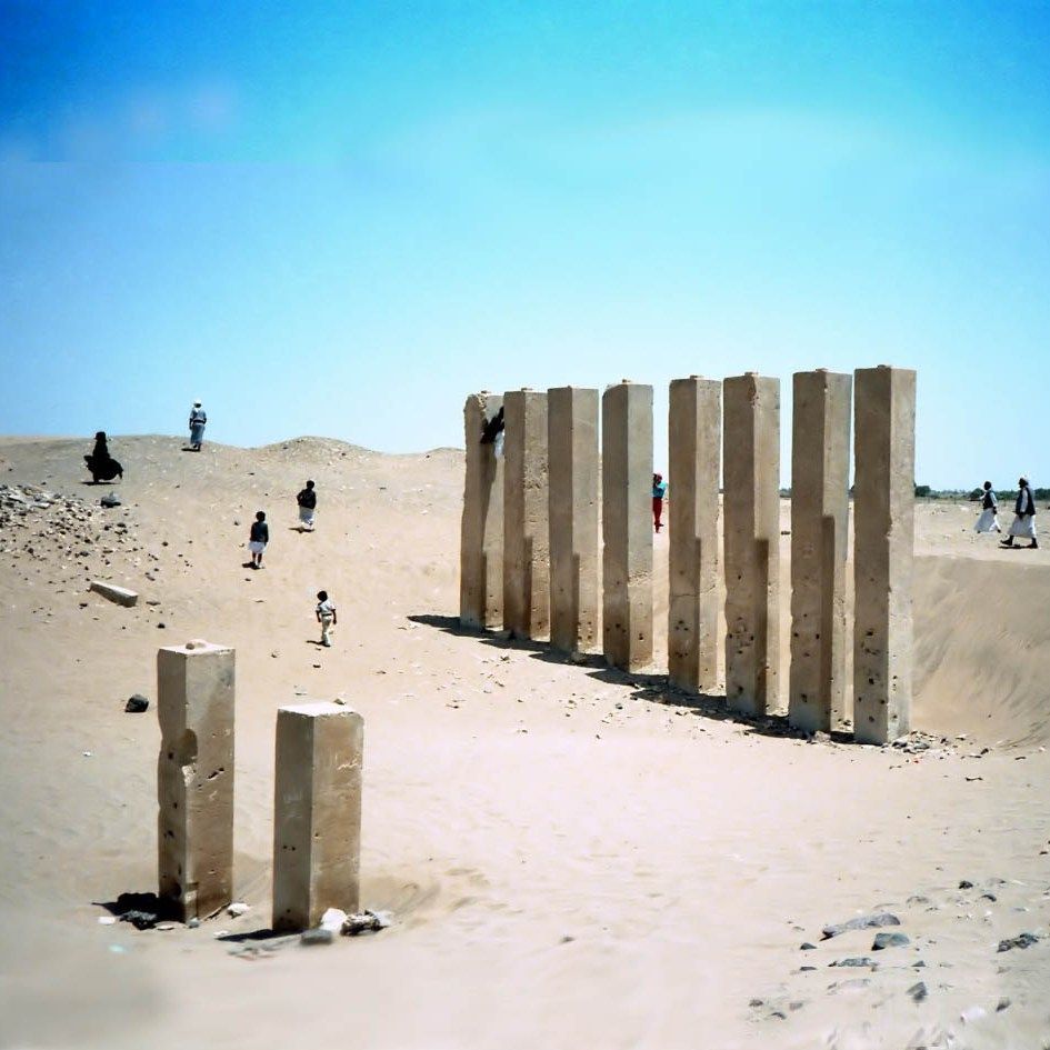
Mahram Bilqis
The famous concrete technique is easy to recognize. The situation in the photo is before the excavations.

Mahram Bilqis
The nearby Temple of the Sun has recently been restored.

Mahram Bilqis
Only a small part of Mahram Bilqis has been cleared of sand

Mahram Bilqis
Is this the throne room of the Biblical Queen of Sheba?
In the north of Yemen, 120 km east of Sana'a, near the town of Marib, there is a mysterious ruin, still half buried under the sand. Precise location 15 24' 15.50” N, 45 21' 28.91”E. It is known as the Mahram Bilqis Awam Temple of the Moon. According to tradition, this holy place is attributed to the Biblical queen of Sheba. Although there is no historical indication that she actually existed, she is thought to have lived around 960 - 920 BC. The Koran also tells of this queen who visited King Solomon in Jerusalem but unfortunately, no evidence of this has been found during the (so far limited) excavations.
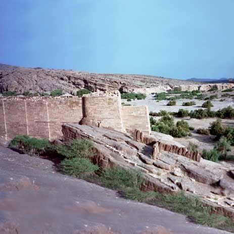
The temple is surrounded by a 260 meter long wall that is 3.5 meters thick and must have originally been 16 meters high. In the hall of the temple there are still some 4.25 meter high pillars, but there were once 32 that supported the roof. The eight monumental pillars that seem to look out over the complex like sentinels, look as if they are made of cast concrete, polished so smoothly. The studs at the top of the pillars indicate that they were once attached to lintels.
Archaeologists date this temple to 1500 – 1200 BC, well before the time of Solomon and Sheba.
Nearby (15 24' 10.64” N, 45 20' 36.13” E) is the Temple of the Sun. This has now been completely excavated and restored. Here, 5 mighty pillars tower above the complex. These pillars also look as if they were made with a concrete technique (Part-IV, Ch.3)
See also the mystery of the Marib Dam.
Marayoor
India
2500 BC?
10.15N 77.11W
Marrayoor
All dolmens are made of granite.

Marayoor
Sometimes a dolmen just seems to be a house.

Marayoor
Most dolmens are small and may have served as burial grounds.
There are numerous dolmens in India. These are located in Marayoor, an area in the Idukki district in the Kerala state in southern India, 42 km north of Munar. The dolmens usually consist of 4 upright slabs with a capstone on top. They are all made of granite. Some dolmens are so precisely carved that they are thought to date from the Iron Age, while the less beautifully crafted stones are said to date from the Stone Age. Many of the dolmens are small, no higher than 1 meter and often underground, but there are also larger dolmens.
It is thought that these are cemeteries because remains of funerary urns have been found in the area, but clear evidence is lacking. They are usually arranged in groups of 2 or more, which is seen as an additional indication of their grave function.
In the Stone Age, the same types of dolmens were built in remote areas such as Western Europe, the Caucasus, Korea and India. Was the same idea invented in different places, or did the inhabitants of those areas have contact with each other (Part-III, Ch.3)
Marib Dam
Yemen
2000 BC?
15 24' 11.17" N, 45 15' 57.79" W

Marib Dam Yemen
Important parts of the Marib dam are still in good condition.

Marib Dam
The Marib Dam was 580 meters wide.
Marib Dam
The Marib Dam has not been rebuilt anymore after the last breakthrough in /- 570 AD. .
In the north of Yemen, 120 km east of the city of Sana'a, near the town of Marib, an ancient dam can still be visited. Archaeologists have determined that the first construction took place more than 4,000 years ago, but many renovations have taken place since then. Today, the structures on which the dam acted, the overflow and locks, are still present on the hills on the north and south sides. The dam had a width of 580 meters, was originally 4 meters and later 16 meters high, and provided irrigation for a large area, allowing the kingdom of Sheba to flourish. The precise location of the northern side is 15 24' 11.12”N, 45 15' 58.06”E, of the southern side 15 23' 51.28”N, 45 16' 07.64”E.
In his book “Are We Children of the Gods” Von Däniken describes the mysterious dam in detail where he rightly dwells on the advanced construction method: without joints, the gigantic walls were still able to effectively hold back the water and transport it along channels to the right place.
Nowadays there is a modern dam, some distance upstream.
Masuda
Japan
? A.D.?
34 40' 48.68" N, 131 51' 35.18" W

Masuda
This strange rock is located in the jungles of the Riva Mountains
Masuda
Sharp corners as if it is easy to make

Masuda
You won't find a rock like this anywhere in the world

Masuda
Traces of processing are still visible on the back
Somewhere in the hills of the Miva Mountains in Japan, near Lake Masuka, in an almost inaccessible place, there is a strange block of hard rock. As if it was thrown down from heaven. It has an exceptionally strange shape, partly due to the two square holes.
The stone is approximately 11 meters long, 8 meters wide and approximately 4.7 meters high. The top surface is smooth and in some places on the side you can see traces of the stonemasons. Why this stone was placed here on top of the Miva Mountains is a mystery. It is also unknown what the square holes were for. These holes have smooth surfaces and sharp corners that require the same advanced stone technology found in Egypt and South America.
The Masuda stone is yet another example of inimitable technology: applied in an inaccessible, remote place, and apparently without any useful purpose.
Is it merely to demonstrate the superior technology? To impress ordinary people who had no idea how to model such a hard block of stone? Who worked this stone, how and why?
Menga
Spain
2500 BC?
37 01' 26.37" N, 04 32' 46.89" W
Menga
Menga is located on top of a hill, an impossible place to drag megaliths to.

Menga
The walls consist of enormous colossi.
Menga
There is no pin between the pillar and the ceiling.
Menga
The construction reveals a concrete casting technique
Menga is located on top of a large hill, in the south of Spain, near Antequera. You could say it is a dolmen, embedded in the top of the hill. The largest deck plate is estimated at 180 tons. Tourist brochures say that this structure was built around 2500 BC. It was excavated in 1842 and human remains were found there. How old it really is is unknown, as is who built it and why. But it is clear that no man at that time was able to cut out a block of stone weighing 180 tons, transport it to the top of a hill, and also position it precisely. Remember that the underside of the roof panels, the ceiling of the room, has been made neatly flat. That also makes it extra complex. According to the same tourist brochures, this structure served as a burial chamber, but nothing can be said with certainty.
The three pillars in the middle support the roof in an elegant way, as if the roof weighs almost nothing. The upright plates fit together perfectly with no gap in between. The structure is so extraordinary that only one conclusion is justified: the prehistoric engineers were very intelligent, had advanced engineering techniques at their disposal to design, construct and transport it (Part-I, Ch.4).
Mnajdra
Malta
3300-2500 BC?
35 49' 36.41" N, 14 26' 10.80" W

Mnajdra
Mnajdra, thousands of years old, is located a stone's throw from the coast and is still relatively intact.

Mnajdra
Huge blocks have been erected, each weighing several tons. Some blocks are still intact.
Mnajdra
This hole serves as an access opening to one of the rooms.

Mnajdra
Despite the large gaps between the blocks, it is clear that the stones are modeled mirror-image symmetrically.
The Mnajdra Temple is located on the main island of Malta and is one of the best preserved megalithic temples in Malta. As with the other temples of Malta, Ggantija, Hagar Qim and Tarxien, the question is whether this 'temple' served as a place of worship or whether it served another purpose.
The architecture is characteristic of Malta: a shape reminiscent of a trefoil with walls consisting of two parallel walls at a distance of 2 meters. The space between the two walls is filled with stones and sand. It is a sturdy wall that has been there for several millennia. The length to width ratio is roughly 40 by 30 meters and some of the megalithic blocks are more than 6 meters high.
It is unclear whether there was ever a roof on top. The walls do not seem to be made to support megalithic roof slabs.
Long ago, in 1840, the temple was excavated. It is assumed that the temple was built in the period 3300 BC - 2500 BC, but these dates have never been scientifically determined.
There are many question marks. Why is this temple here, on an island, far from civilization? Or was the island not an island at all in ancient times, but connected to the mainland? And who cut and transported the enormous stones? (Part-II, Ch.2)
Mycene
Greece
1500-1000 BC?
6 50' 40.55" N, 158 20' 08.18" W

Mycene
The access road to Mycenae

Mycene
This stone which consits of hard pebles, is cut as a knife through butter: extremely smooth

Mycene
The surrounding wall is built without cement

Mycene
The wall plaques of the burial chamber of Mycenae fit together seamlessly
Mycenae is located in the interior of Greece, in the Peloponnese. It is a curious place as it is neither a city, village, fortress or place of worship. It is located on top of a hill, on different floors, but the ruins do not indicate the existence of beautiful buildings or palaces. Only the entrance gate makes any impression due to the carved lions above the entrance, giving it the name Lion's Gate.
But for the observant visitor, this complex is shrouded in mystery, because there are remarkable things to see that can hardly be explained. For example, the mountainside in front of the Lion's Gate contains large blocks of stone containing a lot of rock-hard gravel, cut and polished as if it were a pack of butter. The large wall to the right of the Lion Gate consists of several parts with polygonal stones, as if different architects were allowed to do their thing (Part-I, Ch.3)
N
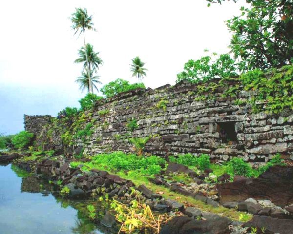
Nan Madol
Micronesie
1250 AD?
6 50' 40.55" N, 158 20' 08.18" W

Not Madal
Built in and on the water
Non Madol
Numerous basalt pillars

Non Madol
Forts and Temples?

Non Madol
Who were the builders of these remarkable structures?
On the island of Pohnpei (formerly Ponape), almost 2000 km northeast of New Guinea, there is a remarkable ruin, Nan Madol. This ruin consists of a number of buildings constructed from basalt rods. Some structures are in the water, and there is even a tunnel that runs completely underwater to the sea. This suggests that Nan Madol must be very old when the water level was much lower than today, but the official statement is that it was built around 1250 AD. has been built.
Nasca
1400 - 500 BC
Peru
13 15' 26.14 Z, 72 16' 02.68” W
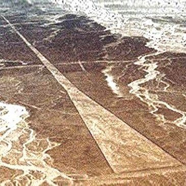
Nasca
Some strips in the Nasca line pattern look like runways.

Nasca
A riverbed crosses the 'airstrip'. But since time immemorial, this area has been bone dry all year round, which suggests that the Nasca Lines are extremely old.

Nasca
Who ever took the trouble to draw this enormous drawing on the mountainside?

Nasca
There are dozens of wells in the plains of Nasca. Some lines end at such a well
There is a desert-like area on the east coast of Peru, 370 km south of Lima, near the town of Nasca (Nazca). It is a limestone plateau strewn with grit and small stones. In earlier times, lines and planes were plotted here by simply removing the surface material to release the yellow background. The lines are tens of kilometers long and go straight through the landscape, regardless of obstacles such as old riverbeds and hills. Giant drawings of animals have also been released in this way. The remarkable thing is that these lines and drawings are so large that they can only be recognized from the air.
Some of these lines meet at one point. There is usually a well there, which is probably connected to other wells by underground passages. In addition to lines, there are also trapezoidal surfaces that seem to suggest that these were once aircraft runways. A few ends on a specially flattened hill.
Archaeologists associate these remarkable lines with the Nasca culture, but there is no convincing evidence as to who created these patterns and why.
O
Ollantaytambo
? v/n. Chr.
Peru
13 15' 26.14 Z, 72 16' 02.68” W
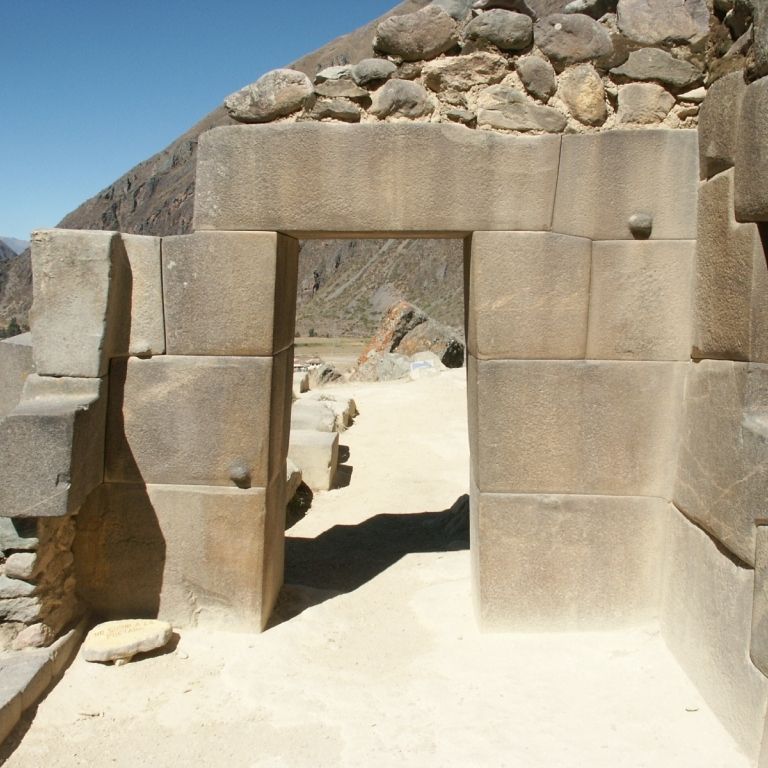
Ollantaytambo
To reach the higher part you have to go through a very beautifully designed gate. The stones have a steel-like appearance and fit together seamlessly.

Ollantaytambo
These exceptionally beautiful walls and trapeze-shaped gate make a stunning impression on every visitor who visits the Ollantaytambo complex.

Ollantaytambo
This almost 3 meter high wall is located in the most central part of the complex. It consists of 6 huge stones, between which there are narrow stones, like a joint. It is a curious structure that seems to serve no other purpose than to impress the viewer.

Ollantaytambo
It is unknown who built this wall, but it testifies to a virtuoso architectural art that has not been equaled to this day.
High on a jutting rock near the village of Ollantaytambo in Peru is a mysterious temple or fortress complex. It consists of a number of ascending terraces along which the ascending path runs that gives access to the highest part. There are a large number of houses or rooms built from rough chunks of stone. We also find a number of remarkable constructions. Firstly, a long wall along the access path that consists of the most beautifully designed stones in South America: as if it were made of polished steel. At the end of this is a perfect gate that leads to a strange, messy place above: large blocks scattered as if the construction was never finished, or perhaps destroyed by an earthquake. In the middle of this is an approximately 3 meter high wall of approximately 7 meters in length, consisting of five megaliths. This strange wall seems to serve no purpose other than to impress. It is claimed that the stones of this wall were brought from the mountains on the other side of the valley but there is no evidence to support this claim (Part-II, H.11).
to Mystery to HOME up
Olmec
1500-500 v. Chr.
Mexico
-90N, 0W

Olmec
The African appearance reveals that the Olmecs crossed the Atlantic Ocean

Olmec
Each head wears a kind of helmet, but each helmet is decorated differently.

Olmec
The mysterious Olemec heads are made of hard volcanic basalt.
Olmec
If it weren't the hard basalt you would suspect that this head was made with a modeling technique
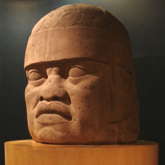
The Olmec are a mysterious people. Hidden in the mist of history, they appear to us as 'the mother people' of the tribes in Mexico. Who they were, what language they used and where they disappeared to is unknown. They lived in the period 1500 – 400 BC. in the lowlands on the Gulf of Mexico, about halfway along the eastern coastline.
This mysterious people left behind a number of enormous stone heads, making it famous today. About 17 heads have been excavated, and no two heads are alike. All appear to represent an African person, and all are wearing a helmet or have a helmet-like hairstyle.
The size of the heads ranges from 1.5 meters to 3.4 meters and they weigh tens of tons. They are made of hard volcanic basalt.
The African origin is of course too controversial for the average archaeologist, but is there another explanation possible? Is it really so impossible that Africans were present in this part of the world and played such an important role that such large statues were created to honor them?
Some heads have such a specific surface structure that sculpting is not the obvious method. If it were not basalt, one would be more inclined to accept that these heads were made using a modeling or casting technique, after which the material was hardened. (Part-III, H.13)
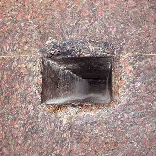
Osireion
< 1400 BC?
Egypt
26 10' 43.40” N, 31 54' 58.57” W

Osirion
The Osirion temple is located a few meters deeper than the temple of Pharaoh Seti -I.

Osirion
The Osirion is below the current groundwater level.

Osirion
No hieroglyphs have been found on the granite stones of the Osirion: the walls are completely bare.
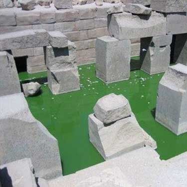
Osirion
Even the largest blocks have been severely damaged, but it is unknown how this ever happened.
The Osirion Temple is a strange building that stands next to the temple of Pharaoh Seti I in Abydos, Suhag, 45 km north of Luxor in Egypt. It was discovered in 1902 by Petrie and Murray. The building is located a few meters lower than the temple of Seti I. The construction is strange because it has a different style, consists of enormous blocks of granite, some of which weigh more than 100 tons. The surface of these stones are 'polished smooth' and appear to be crafted with 'machine precision'. There are no inscriptions in these blocks, except some crude signs which must have been added in later times.
When the temple was discovered it was completely filled with desert sand. Today the foundation is below the groundwater level which is now affecting the stones due to the salt present in the ground.
The mysterious architecture, the large granite blocks, the extremely smooth surfaces and the absence of signs or drawings makes you wonder who ever built this.
The large temple of Seti I in front of it contains the famous wall sculpture with the king's list. Also here is the bar with hieroglyphics reminiscent of airplanes and helicopters.
P
Pisac
? BC/AD?
Peru
13°24'51.90" Z, 71°50'39.41" W

Pisac
Pisac is located on an inaccessible rock, and like Machu Picchu, next to another higher hill.
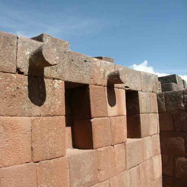
Pisac
The bulges form a whole with the stone.

Pisac
Here you can clearly see how the underlying rock has been carved in such a way that the stone fits exactly into it.

Pisac
Can a stone be cut from friable material so that the face is accurately straight?
Pisac is a mysterious place, 20 kilometers northeast of Cusco in Peru, and only accessible after a brisk walk through rugged mountains. Made up of a number of high-tech stone structures, it sits on the spur of a mountain, and like Machu Picchu, has a higher peak overlooking it.
The structures consist of seamlessly connected large stones, often more or less rectangular, but often also polygonal. Just like in Machu Picchu, there is a so-called Sun Temple here: a wall of perfectly connecting stones that half encloses a remarkable rock. What is so special about that rock that such a special wall had to be built around it.
We also find an Intihuatana there, only not high on a hill but on the ground. Is an Intihuatana not a 'sacred' or 'astronomical' construct at all?
The techniques used are true examples of 'high-tech': seamlessly jointed walls, straight cut-outs, sculpting with hard rock and 'snow shoveling' in hard rock (Part-II, H.11 and Part-IV, H.4)
Piri Reis world map
1513 AD
Topkapi Museum Istanbul
41 00' 41.05" N, 28 58' 59.51" W.

Piri Reis was a Turkish admiral who lived from /- 1470 - 1553. He became known for his accurate map showing Europe and part of Africa, as well as America and part of Antarctica. The special thing about this map is that it is said to have been made in 1513, at a time when nothing was yet known about Antarctica and the southern part of South America. It is suspected that Piri Reis had older maps that he used to draw this map.
Pulemei pyramid
1100-1400 AD?
Savaii island in Samoa
13 44' 06.60" W, 172 19' 27.70" W.

Pulemelei pyramid
A simple but intriguing pyramid
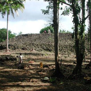
Pulemelei pyramid
Who built this pyramid and when is unknown

Pulemelei pyramid
Thousands of rough stones form this bizarre pyramid

Pulemelei pyramid
Was this once a grave?
The Pulemelei pyramid is the largest structure in Polynesia. It is located on the small Samoan island of Savaii, the island considered by the Polynesian people as the cradle of Polynesian civilization. It is approximately 12 meters high and measures approximately 65 x 60 meters. It stands on a stone base and is oriented along the cardinal directions. It was completely overgrown by jungle but was recently cleared by the research team from the Thor Heyerdahl Research Center in Norway. The pyramid consists of rough basalt stones the size of a football. No carved stones were found, nor a tomb, but legends say that the pyramid was built by the supreme god Togaloa. Settlements are dated to 1000–1400 AD but the actual year of construction is unknown. The original purpose and identity of the builders also remain a mystery.
Puma Punke
17000 BC
Bolivia
16 33' 41.02" W, 68 40' 48.19" W
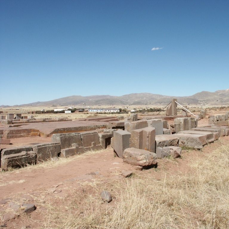
Puma Punke
Puma Punku is now just a collection of stone blocks.

Puma Punke
This block of stone is one of the largest worked stones in the world.
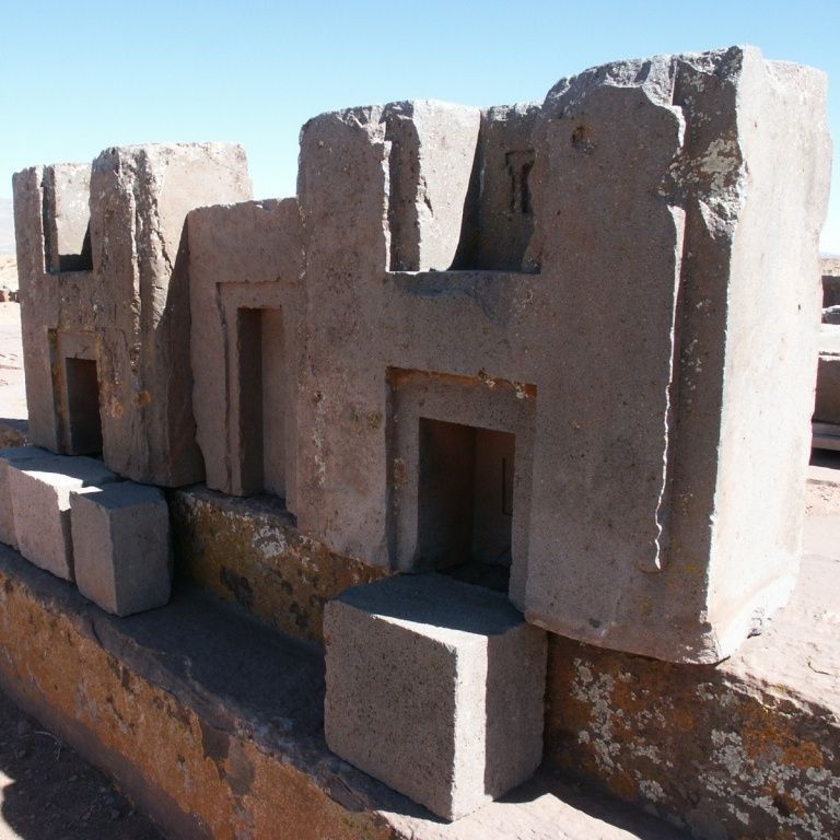
Puma Punke
These blocks are probably the remains of a large wall or building.

Puma Punke
This remarkable column of andesite is perfectly flat on all sides.
In a sparsely populated highland in Bolivia, south of Lake Titicaca, there is a mysterious temple complex, Puma Punku, near the famous Tiahuanacu. It, like Tiahuanacu, is seriously dilapidated due to earthquakes and human vandalism. There is nothing interesting to see in Puma Punku for the average tourist; it is just a collection of large stone blocks. But these hard stone blocks tell a remarkable story: the specific shapes can only be created with advanced techniques such as milling, drilling and pouring concrete. Scientific researchers like Prof. Kolata are astounded and have no explanation for this. The stone blocks are probably the remains of a large and architecturally advanced structure. Technical constructions have been applied that are described as extremely advanced by architects such as Protzen and Nair (Part-II, H.12).
Q
Quenko
? BC / AD ?
Peru (near Cusco)
13 30' 37.10" Z, 71 58' 16.61" W
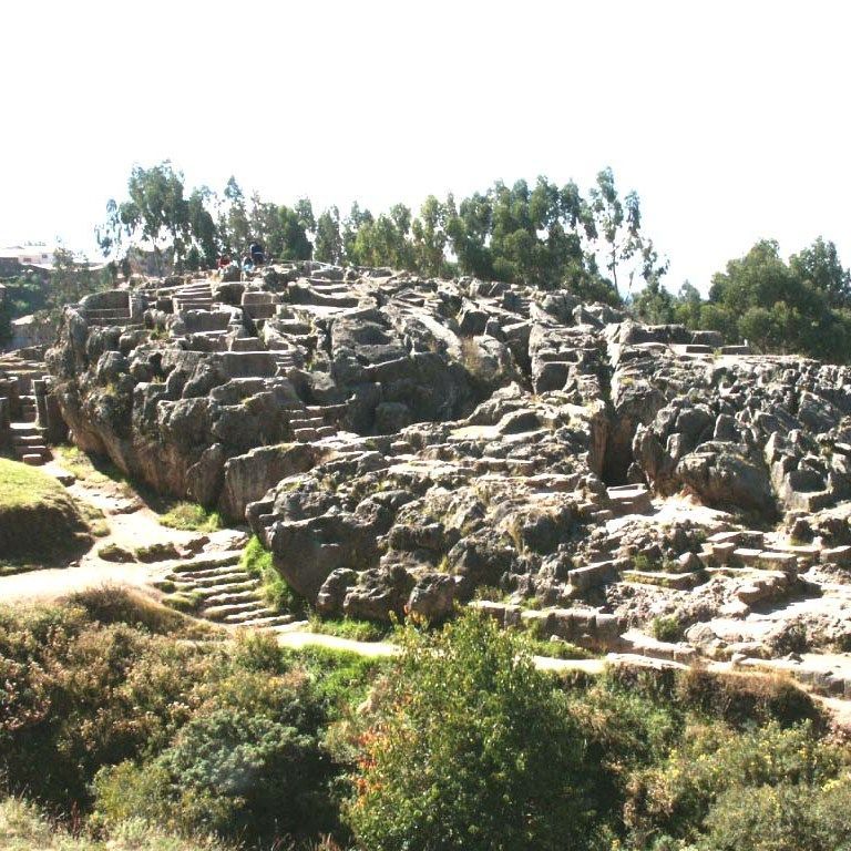
Quenko
Near Sacsayhuaman, near Cusco.
The rock formations of Quenko give the impression that material has been scooped out of the formation with a large shovel, but the rock is extremely hard.
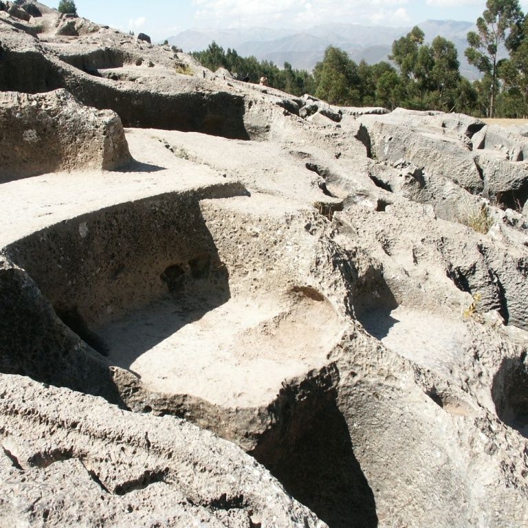
Quenko
The strangest shapes have been carved into the Quenko rock formation near Cusco in Peru.
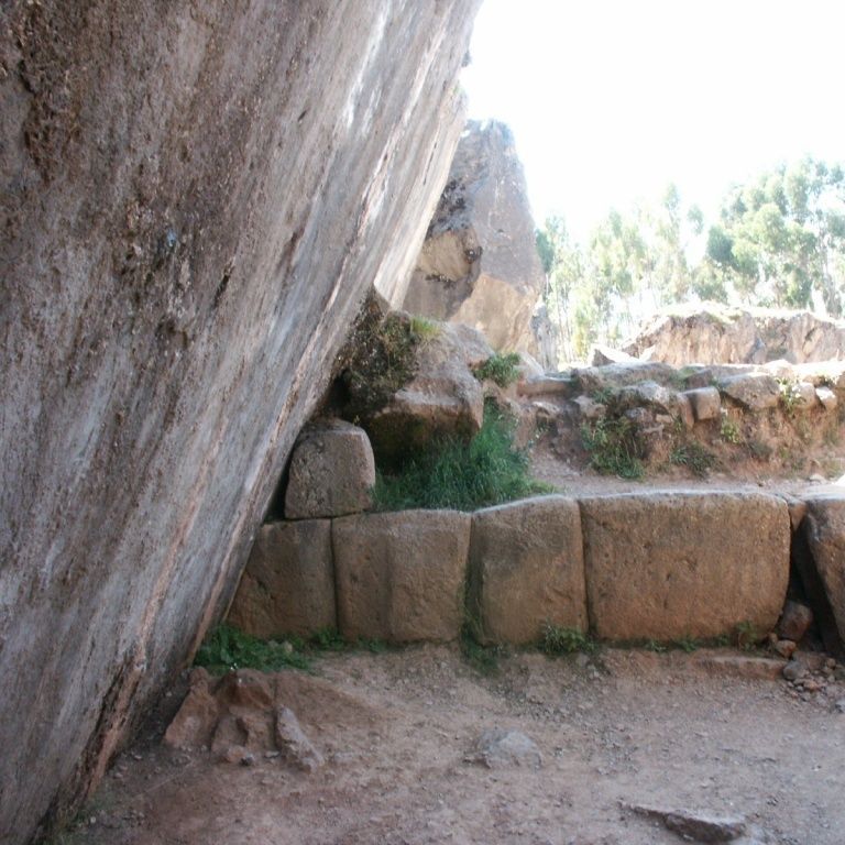
Quenko
For some unknown reason, the wall along the entrance to the space under Quenko is cut at a perfect angle.
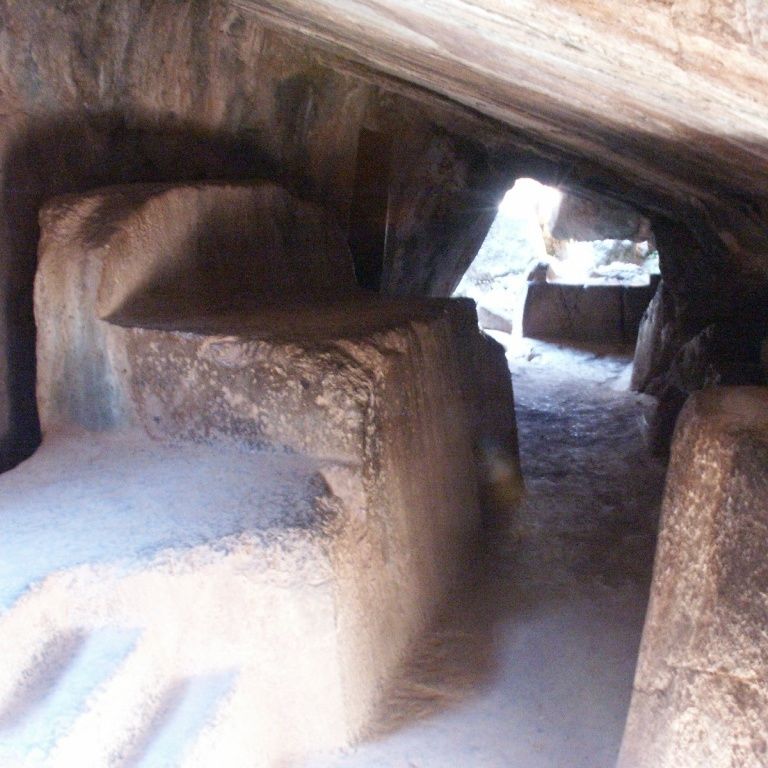
Quenko
Under the Quenko rock formation there is a narrow space where there is a kind of throne, but it is difficult to imagine that this once served as a throne room.
Near Sacsayhuaman near Cusco in Peru is the remarkable Quenko rock formation. In a rolling landscape covered with grass there are a number of hard stone rock formations. Some of them have been carved in a very strange way, as if someone had made recesses with a snow shovel. How this was ever made is a mystery. Below the rock formation there is a very strange narrow space, carved out of the rock formation. Inside is a strange recess that resembles a throne, but there is barely room to sit on it.
The big question is who ever created this remarkable formation, and especially how (Part II, H.11).
R
Roche-aux-Fees
8000 BC?
France (Brittany)
47° 56′ 11″ N, 1° 24′ 17″ W
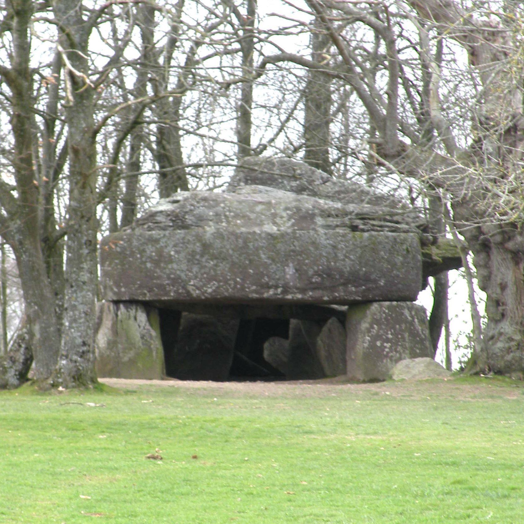
Roche-aux-Fees
This giant makes a stunning impression. How did people ever manage to place such a large stone so precisely?

Roche-aux-Fees
It could have served excellently as an air raid shelter against disaster from above.
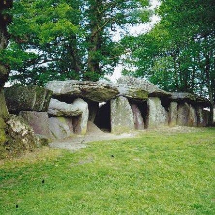
Roche-aux-Fees
There are 28 uprights and 8 cover plates

Roche-aux-Fees
The large front plate lies exactly flat on the uprights with playful ease.
La Roche-aux-Fées is a gigantic dolmen - in the municipality of Essé between Vitré and Châteaubriant in Brittany in France. It is located on a hill and consists of 28 uprights and 8 roof slabs weighing between 20 and 45 tons each. The structure is 19.5 meters long and oriented from the north-northwest to the south-southeast, it faces sunrise during the winter solstice. It is believed that the structure was originally covered by a burial mound (Part-III, H.3).
Rudston monolith
1600 BC?
Britain
54 05’ 38.08” N, 0 19’ 21.00” W
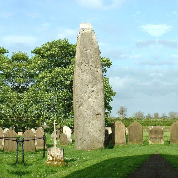
Rudston monolith
The Rudston monolith is the largest in England.
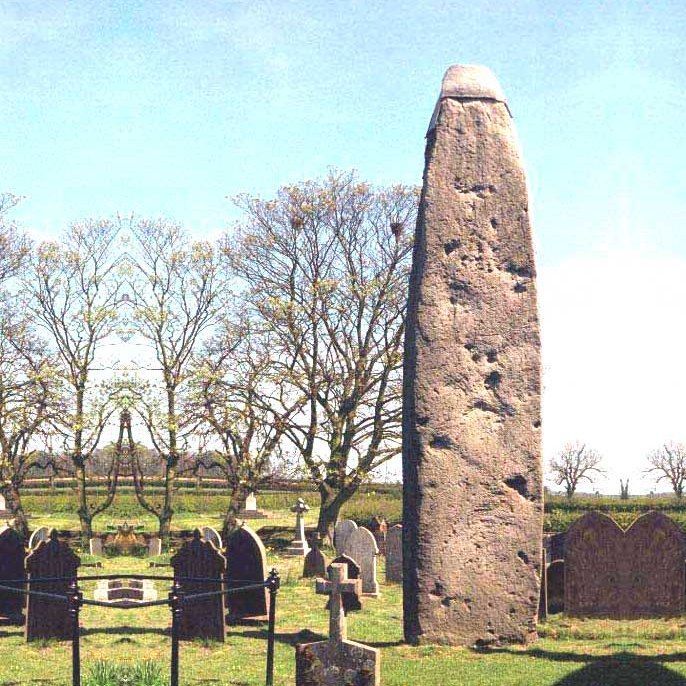
Rudston
It is unknown from what time the monolith dates back or who built it.
Rudston
It is suspected that the monolith was surrounded by a stone circle

Rudston monolith
The Rudston monolith is almost 9 meters long and weighs at least 40 tons.
In the north of England, in the town of Rudston east of York, is the largest megalith in all of Great Britain. Where it comes from and how old it is is not known, but the fact that a church was once built right next to it indicates that this place has always been a sacred place. The nearest possible quarry is 15 km away. The monolith is almost 10 meters long, weighs at least 40 tons and is protected at the top with a lead place to prevent further erosion.
S
Sacsayhuaman
?BC?
Peru
13 24' 44.75" N, 103 52' 00.24" W
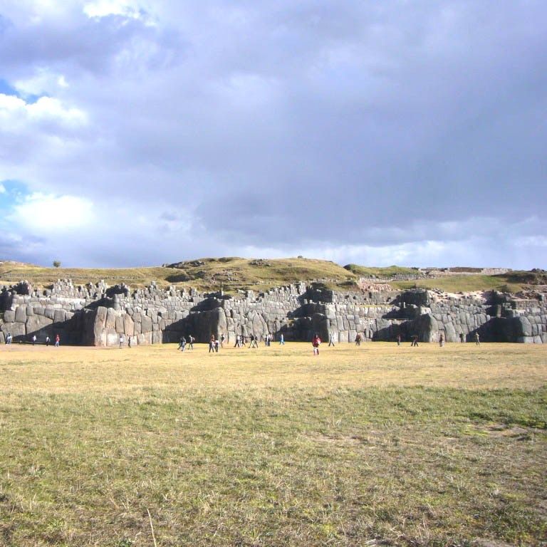
Sacsayhuaman
This structure has no use as a military fortress; it appears to be more of a parade ground where the dignitaries stood on the walls to view the scene below them.

Sacsayhuaman
These behemoths are a mystery in themselves: how do you construct something like that?

Sacsayhuaman
On the hill of twisted rock, the "Inca throne" has been carved with incredible precision

Sacsayhuaman
This rock is upside down: turned over by a huge natural catastrophe, or blown up by the Spanish in search of gold
Sacsayhuaman is located on top of the hills northwest of Cusco in Peru. The most striking feature is the long megalithic wall built into a hill. It has a zigzag shape and consists of enormous stones, some up to 3 meters high, which, regardless of their shape, fit exactly against each other. The wall consists of three floors and therefore resembles a fortress, but it is not: as a defense structure it is no obstacle at all for an attacker. On top of the hill there are remains of buildings, of which the round foundation is the most striking. This megalithic wall has been constructed as if the builders had no difficulty in shaping and placing those gigantic stones against each other. Who were those (prehistoric) engineers? (Part-II, H.11 and Part-IV, H. 4 and 5)
Serapeum Giant stone sarcophagi
600 - 1000 AD?
India
29 52' 33.78" N, 31 12' 36.91.51" W.
Sakkara Serapeum
Precision sculpture made with copper chisels?

Serapeum Saqqara
Granite or diorite?

Serapeum Saqqara
Mirror smooth surface

Serapeum Saqqara
Chris Dunn demonstrates the bizarre precision
The Serapeum near Djoser's pyramid in Sakkara is one of the most mysterious places in the world. It is a kind of underground atomic bunker, discovered by Auguste Mariette in 1851, hundreds of meters long and has 24 large side rooms. These side niches contain enormous sarcophagi. They measure approximately /- 4 x 3.4 x 2.3 meters, are carved from a single block of stone and weigh between 60 and 80 tons, while the lid weighs approximately 20 tons. It is thought that sacred bulls were buried in these sarcophaguses, but no bull has ever been found in such a sarcophagus. Regardless of whether or not these sarcophagi served as the final resting place for sacred bulls, it is a mystery how they were ever able to manufacture and transport these monstrous things.
The dimensions are so large and the smoothness so extreme that even today there are actually no machines in the world that can cut such large blocks from a mountain, hollow it out at sharp angles and polish the inner and outer walls to such an astonishing smoothness .
This precision, in combination with the gigantic dimensions, is beyond our comprehension. Machines to recreate this do not currently exist, and it would cost a fortune to build such machines – it seems complete madness. Extreme high-tech precision stone cutting, drilling and polishing techniques were used here in ancient times. Who were these prehistoric engineers, how did they do this, and why? (Part-III, H.17)
Sete Cidades
? BC / AD ?
Brazil
4 10' 59.85" W, 4 43' 01.13" W

Sete Cidades
Strange rock formations, worked by humans?
Brazil
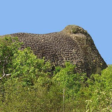
Sete Cidades
There seems to be a huge elephant walking through the forest
Brazil

Sete Cidades
What should we make of this remarkable structure?

Sete Cidades
Is this a fossil tree trunk cleaving the rock?
Sete Cidades is a strange place. If it had been in Europe or the US it would have been famous and would attract many visitors. But because it is located in the inland of Brazil, near the town of Piri-Piri, it is not well known. The area is a forested area, but it is not a jungle. You can only reach it by car. The road there is often bad due to frequent heavy rains. Once you get there, locals will recommend that you continue with their guidance because the area is vast and the things you want to see are very diverse.
Sete Cidades is Portuguese for “seven cities”, but don't expect to find any cities here, not even ruins. There are seven places that are so special that someone once felt it necessary to refer to them as a 'city'. These 'Cidades' contain remarkable constructions: there is still a vigorous debate going on between 'traditional scientists' and 'frontier researchers' as to whether these constructions are a freak of nature or whether they have been created by human hands. The most special are the sandstone constructions that rest on an elephant, reps. look like a turtle. Another oddly shaped mound contains protruding tubes, and the skin of some of the animal-like mounds is so strange that a natural cause seems excluded. From a traditional point of view, the explanation is simple: Over time, the sandstone hills have suffered from all kinds of weather influences, which have created the strange shapes. It could be purely coincidental, for example caused by some catastrophic event that caused huge bodies of water to form the area.
Arguments in favor of a different explanation lie in the fact that there are too many strange constructions, of varying shapes, in a limited area. In addition, engraved strange signs have been found in one of the Cidades, indicating habitation in prehistoric times. (Part-II, Ch.6).
Sphinx
2500 BC?
Egypt
4 10' 59.85" W, 4 43' 01.13" W

Sphinx
The Sphinx, the largest and oldest statue in the world
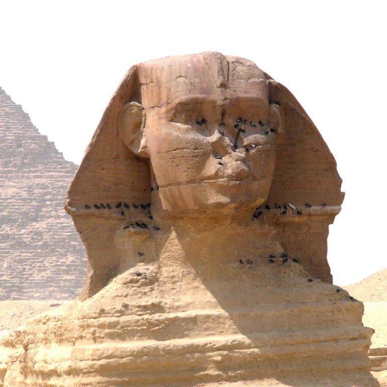
Sphinx
Weathered and battered but still prominent after thousands of years.

Sphinx
The Sphinx has been restored many times over the years
Sphinx
Only the head of the Sphinx protrudes above the limestone plateau.
The Sphinx of Giza is the largest carved statue in the world, and also the oldest. It is 57 meters long, approximately 6 to 8 meters wide and almost twenty meters high. It is made by removing the limestone around it which makes it lie in a pit. The head consists of the harder limestone than the layers of the body. The head with the nemes is too small in size compared to the main mass, which suggests that this is a later modeling of an originally large (lion) head.
But the big question is, how was that sphinx made? The tourist walking past then thinks, "just chop and break, long and patiently". But is that really so? According to common belief, this cutting and breaking took place at least about 4,500 years ago, a time when bronze and iron tools had not yet been invented. Try working on limestone with a copper chisel and stone hammer and you will soon discover that after a few blows the chisel is unusable and you have to return to the forge to be sharpened again. Just think what a gigantic operation that will be. (Part-I, Ch.10, Part-III, Ch.10 and 11)
Stonehenge
~~ 3100 BC
England
51 10’ 44.07”N, 1 49’ 34.49”

Stonehenge
There is evidence that Stonehenge was once a prehistoric astronomical observatory.
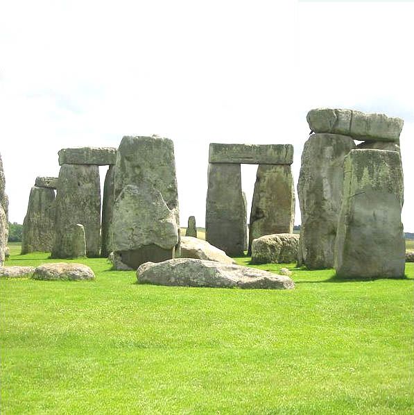
Stonehenge
Some stones have been lying flat on the ground since time immemorial. There are also some missing, or they were never there.
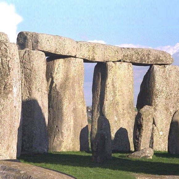
Stonehenge
Stonehenge is said to have been built in several phases over the course of more than a thousand years.

Stonehenge
Stonehenge consists of a number of concentric circles of large stones and an earthen wall.
Stonehenge is a megalithic monument near Amesbury, about 8 miles (13 km) north of Salisbury in southern England. It consists of a number of free-standing megaliths that together form a circle. On top of these stones are lintels that connect the pillars. This construction is surrounded by a circular earth wall and a moat with a diameter of approximately 110 meters. There is one on the north side, and one on the south side. The standing stones are approximately 4 meters high, 2 meters wide and 1 meter thick, and weigh 25 tons. A complete circle would have required 74 stones, but now some are missing or were never there. The lintels are approximately 3.2 meters long, 1 meter wide and 0.8 meters thick.
According to archaeology, the structure was built in several phases between 3100 BC. and 2000 BC, but the oldest remains date from 8000 BC.
The purpose of this mysterious place is unknown. It is suspected that it has a religious or astronomical application, but who were the people who could make the enormous effort to build this? It is certain that the stones did not come from the immediate area. Some stones are believed to have come from Wales at a distance of 250 km. it is unclear how in ancient times one could perform such a task without appropriate tools.
T
Tap-O'Noth
~~ 1000 BC
Scotland
57 20' 58,90" N, 12 51' 34,87" W

Tap O'Noth
The ruins of Tap O'Noth are strategically located on top of a hill.
Scotland

Tap O'Noth
The walls of the fortress have been destroyed
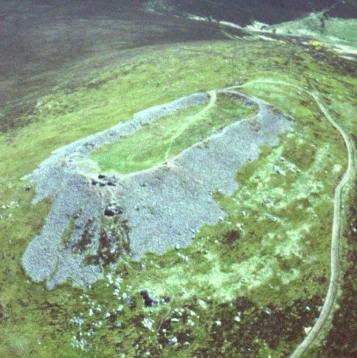
Tap O'Noth
A hellish fire has melted the stones

Tap O'Noth
Incredible but true: the stones are sintered together.
Ruins of forts can be found in many places in Scotland, Ireland and Brittany. These were destroyed with brute force in such a way that the stones were melted and sintered together. But to melt hard stone requires an exceptionally high temperature, something that can only be achieved in a special furnace but not in the open air, otherwise it would require an atomic explosion. Science has been trying to explain this mystery for a hundred years, but so far without convincing results. Can we then attach value to the local legends that say that at the time all-powerful gods attacked each other over great distances with super-powerful weapons? Besides Tap O'Noth, there are dozens of other 'glazed forts' in Scotland, Ireland and Brittany. (Part-II, H.6 and Part-III, Ch.6)
Tarxien
3600-3000 BC?
Malta
35 52' 09.31" N, 14 30' 43.64" W
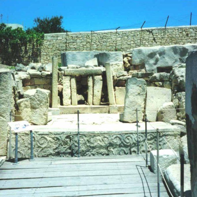
Tarxien
Tarxien looks a bit messy, but if you look closely you can recognize different architectural styles.

Tarxien
Note the precisely fitting stones and the plasterwork

Tarxien
Tarxien is located in the middle of the current city of Valetta and is still relatively intact.

Tarxien
This throne is at the end of a narrow corridor, not exactly a 'throne room'. It resembles the stairs in the Yonaguni submarine structure.
The Tarxien Temple is located on the main island of Malta and is located near the underground temple complex, the Hypogeum Hal Saflini. As with the other temples of Malta, Ggantija, Mnajdra and Hagar Qim, the question is whether this 'temple' served as a place of worship or whether it served another purpose.
The architecture is characteristic of Malta: a shape reminiscent of a trefoil with walls consisting of two parallel walls at a distance of 2 meters. The space between the two walls is filled with stones and sand. It is a sturdy wall that has been there for several millennia. The length to width ratio is roughly 40 by 30 meters and some of the megalithic blocks are more than 6 meters high.
It is unclear whether there was ever a roof on top. The walls do not seem to be made to support megalithic roof slabs.
This temple was excavated between 1910 and 1920. The temple is built in the time frame 3600 BC - 3000 BC, but these dates have never been scientifically determined.
There are many question marks. Why is this temple here, on an island, far from civilization? Or was the island not an island at all in ancient times, but connected to the mainland? And who cut and transported the enormous stones? The stairs to the throne are very reminiscent of the stairs in the submarine Yonaguni (Part-II, Ch.2).
Teotihuacan
500 BC?
Mexico
19 41’ 33.09” N, 98 50’ 37.68” W
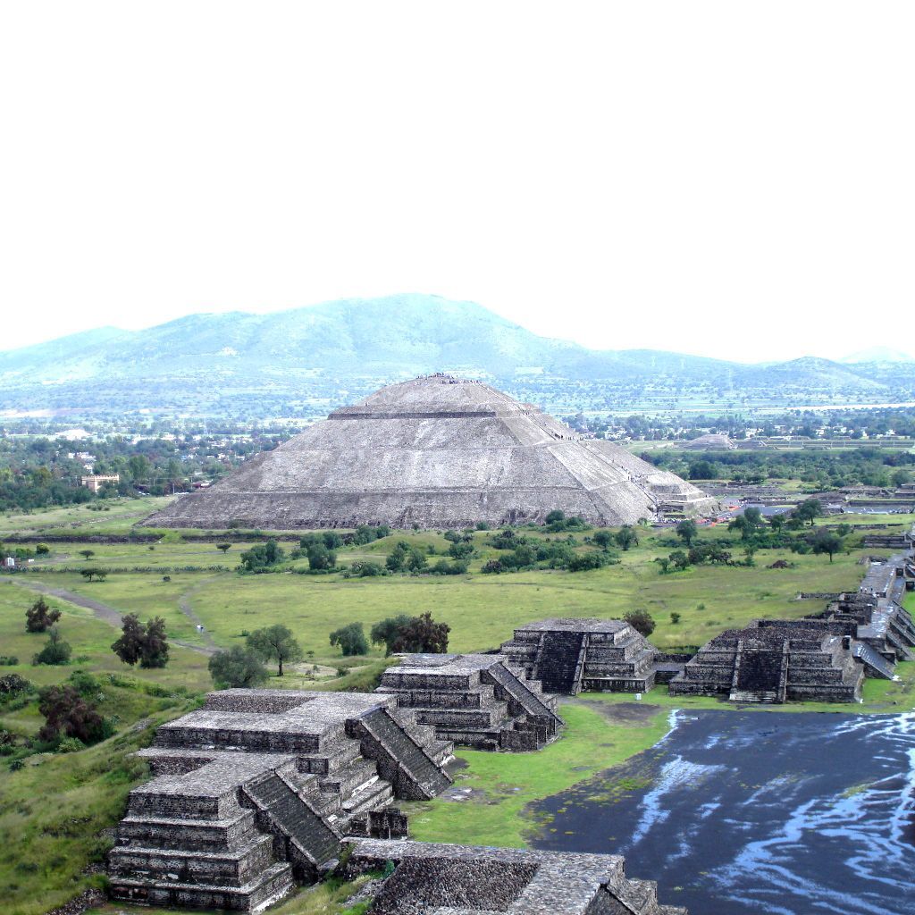
Teotihuacan
The Sun Pyramid of Teotihuacan
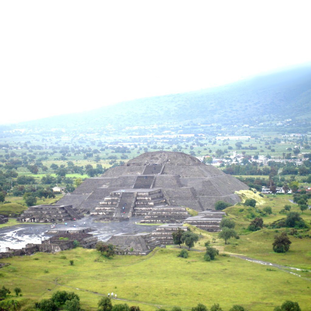
Teotihuacan
The Pyramid of the Moon

Teotihuacan
After a rain shower, the original purpose of the Teotihuacan complex becomes apparent

Teotihuacan
Where did this mica come from, and what was its purpose?
The Teotihuacan complex, the 'City of the Gods', is the most famous pyramid complex in Mexico. The city is located near Mexico City and dates back to several hundred years BC. The Great Pyramids, the Pyramid of the Sun and the Pyramid of the Moon are said to have been built in the first century AD.
There are tunnels under both pyramids, but their function is unclear.
Huge amounts of stone and plaster were used to build the pyramids and temples, demonstrating exceptional manufacturing and logistical skills. The plaster and cement are still of good quality. The question is why no houses for ordinary people, nor viaducts, bridges or roads, have been built with this technology. The construction of such a pyramid took decades, and so one must have been able to make and implement construction plans long in advance. It is unknown who or which people built these pyramids. Who were these exceptionally gifted engineers who built these impressive buildings but made no effort to make the lives of ordinary people easier?
Until 1905, the Pyramid of the Sun was buried under a 4 meter thick layer of sand. This layer was deliberately applied before the complex was abandoned for good. The reason for this remains a mystery for now. In the years after 1905, the layer of sand was removed - revealing a thick layer of mica at the top of the pyramid. That layer was excavated and sold (Part-III, Ch.7).
Tiahuanaco
17000 BC
Bolivia
16 33' 17.14" W, 68 40' ' 23.93" W
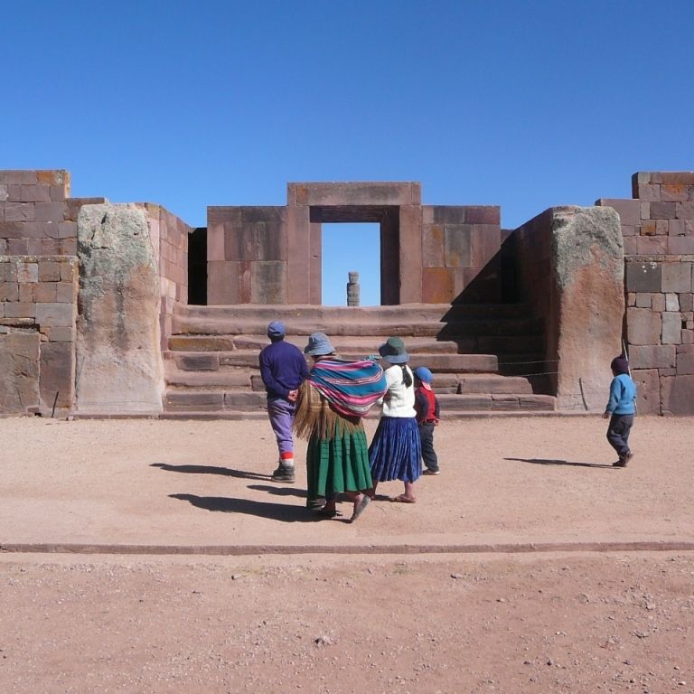
Tiahuanaco
The entrance gate of Tiahuanaco is a contemporary reconstruction

Tiahuanaco
The world-famous Sun Gate was once part of a wall

Tiahuanaco
No doubt about it: casting and plastering techniques were used here

Tiahuanaco
Only the pillars in the walls are authentic
Lonely and deserted, Tiahuanaco is located on the barren plateau of Bolivia. One of the most mysterious places on Earth. It is seriously dilapidated due to earthquakes and human vandalism. In this area we find: an Akapana pyramid, remains of temples and courts, such as the Kalasasaya, walls and the famous Sun Gate. Recent restorations may now give an impression of what it once looked like, but in fact mask the original structure. The buildings were built in different periods. Dating techniques based on the C14 method tell us that the area was inhabited in the first centuries of our era. On the other hand, based on the same astronomical analysis that characterized Stonehenge, Tiahuanaco is 17,000 years old, making it the oldest structure in the world.
Extremely advanced stone technology has been applied in Tiahuanacu. Scientists are astonished at the sight of this 'excessive design' as they call it. In the Akapana pyramid, water flowed in a special way from one level to another through these stone pipes. Instead of thinking of a specific technical use – such as an industrial process to treat water in a certain way – science portrays this pyramid as a sacred scale model for the impressive mountains where mountain streams run from one rock to the next. (What a fantasy!). Mythology tells that man was once created here by 'gods'. It is almost certain that ordinary people were not allowed to enter the area, or at least not to live there: no remains of living quarters have been found. Everything indicates that 'beings' were at work here who did not want ordinary people to get in the way... (Part-II, Ch.11 and 12).
Plain the Jars
? BC/AD?
Laos
19 25' 47.97" N, 103 09' 13.20" W

Plain of Jars
Who ever made these jars and why is a complete mystery

Plain of Jars
The jars are spread out, but often gathered in groups over a large area in Laos

Plain of Jars
The jars are often unfinished and sometimes half sunk into the ground

Plain of Jars
The jars have different sizes
In the interior of Laos there is a mysterious plain. It is littered with large jars carved from solid stone. The size varies from one to several meters. There is nothing to deduce where these jars come from or who made them. It is said that the jars are positioned to mimic constellations. The nearest quarry where these jars could have been quarried is 80 km away (Part-III, Ch.16).
X
Xian
? A.D.?
China
37 45' 44.07" N, 126 26' 26.4" W
Xian
All pyramids in China are made of sand and stone

Xian
Most pyramids in China served as tombs.

Xian
Most Chinese pyramids have a flat top.

Xian
The first photo of a Chinese pyramid was taken by the American Gaussmann in 1947.
It has only recently become known in the West that a large number of pyramids exist in China. In an area (~ 340 23'N, 1080 42'E) measuring 62 km by 12 km, north of the city of Xian, there are about 25 pyramids. The largest of these is located near the famous 'Terracota Army' (340 22' 53.07”N,1090 15' 14.49”E) and with a base of 350 x 370 m is significantly larger (but lower) than the Great Pyramid in Egypt , but still smaller than the largest pyramid in the world, the Cholula pyramid in Mexico which has a base of 450 x 450 m.
The existence of pyramids in China was only discovered during the Second World War by the American pilot Gaussmann. The pyramids all appear to have been built with sand. And almost all pyramids have a flattened top. They have varying sizes, and some are round (34 19' 13.93”N, 108 35' 37.94”). Many pyramids served as funerary monuments."
Y
Yonaguni
10000 BC?
Japan
26 17’ N, 126 30’ W
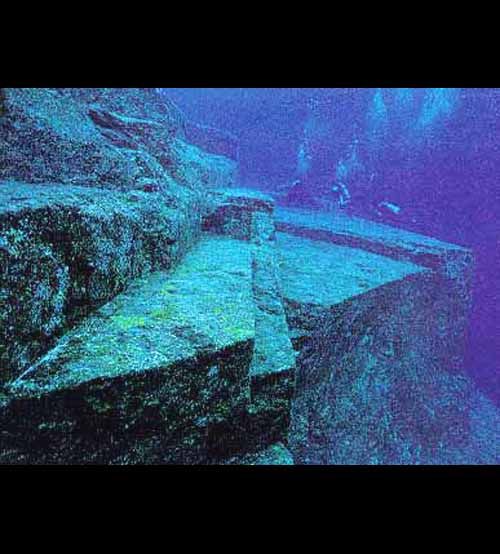
Yonaguni
The vertical planes are at an acute angle to the horizontal planes as if to prevent ascent.

Yonaguni
Yonaguni consists of five levels of horizontal surfaces that have been carved out of the rock bottom
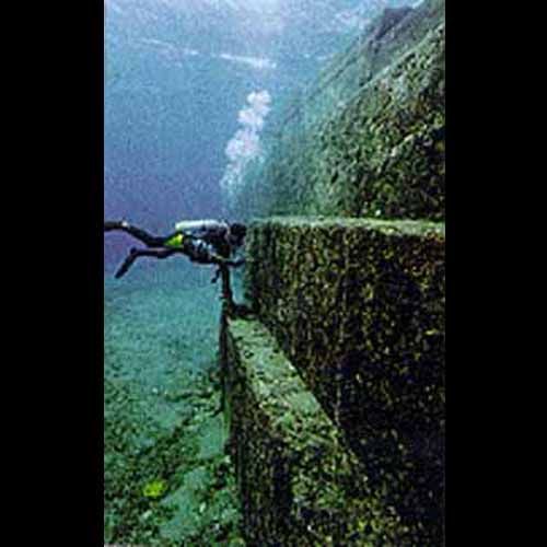
Yonaguni
Even deep under water, the high plateaus make an imposing impression.

Yonaguni
In a narrow corridor there is a staircase that is very reminiscent of the stairs in front of the throne in the temple of Tarxien in Malta.
One of the most amazing structures is Yonaguni. A strange underwater zigzag structure. Yonaguni is a Japanese island near Okinawa and Taiwan. In the mid-1990s, this structure was discovered by diver Kihachiro Aratake in the clear but very wild waters off the coast of Yonaguni.
It is a 5-layer platform cut into the rock bed. It has sleek surfaces and precisely designed corners. It is about 200 meters wide and 35 meters high. Since it is located approximately 30 meters below sea level, it is at least 10,000 years old due to the fact that during the Ice Age the sea water was much lower than it is today.
This means that this structure is one of the oldest structures in the world, together with the Sphinx in Egypt and Tiahuanacu in Bolivia.
What it was used for is unknown.
Imagine if this structure stood on the coast of Japan, long ago. With its multiple platforms, its strange shapes and its enormous size, it must have made a huge impression on any visitor.
It is difficult to examine the structure due to strong ocean currents. As a result, there are still countless questions to be answered by underwater archaeologists.
The stairs at the end of the narrow corridor are very reminiscent of the stairs in Tarxien that lead to a throne.
9640 v.Chr.
Acropolis

Greece
According to current history, the Temple of Athena was built on the Acropolis in the 5th century BC. But in the Kritias, Plato, who lived from 427 – 347 BC, describes that the city of Athens was founded in 9640 BC. was founded by the goddess Athena. At that time, the Acropolis was not yet a table mountain, but was part of a rolling hilly landscape on which there was very fertile agricultural land. The climate was very temperate, different from today.
But a catastrophe occurred at that time, and in one night with exceptionally heavy rain, accompanied by heavy earthquakes, the earth was completely washed away. So now only the hard rocky ground remains.
The state of Athens had a great reputation because it was the only one to resist the enormous superior forces of the army of Atlantis that threatened Europe. But Athens managed to defeat this mighty army.
The goddess Athena founded the city of Sais in Egypt 1000 years after the foundation of Athens, which started the development of Egypt.
37 58' 28.09" N, 23 43' 09.62" W.